Toward White Pine Lake….
The trail-head for White Pine Lake is located about 5.5 miles up into Little Cottonwood Canyon, which is just south and east of Salt Lake City, Utah, USA. This is the same trail-head used to access the Red Pine Lakes, both Lower and Upper. The drainage, or tributary canyon/fork that leads to White Pine Lake is just east of the one leading to the Red Pine Lakes. You might remember my three earlier posts on Upper Red Pine Lake. You can refresh your memory by clicking here, here, and here to revisit those posts. The trail to White Pine Lake is just over four miles in length and has an elevation gain of a little more than 2,300 ft…the lake is situated at around 10,000 ft.

In his book, The Lady in the Ore Bucket, Charles L. Keller tells us that lumber operations were conducted in this area from the mid-1860’s until about 1881…the area was referred to as the White Pine Fork of Little Cottonwood Canyon.

I haven’t found precise dates for it, but mining operations were also conducted in the area, with work possibly continuing into the early to mid 1900’s. I offer the date of the early 1900’s because I have found a bit of narrow-gauge rail along the shore of White Pine Lake that was similar to other rail that I found at a different location in Big Cottonwood Canyon that had a production city and date on it…but I’m really guessing here….
Can you find the two people in the below photograph? They’re about one-third of the way up and just to the right of the large rock in the center of the bottom edge of the photo.

Keller references mining operations in Little Cottonwood Canyon proper, mostly around the area of Alta, but does note several times that miners referred to their claims in the White Pine Fork. I have found an article by David A. John which details the reported amounts of precious metals taken from the ground in the Central Wasatch Mountain area, but again, nothing specifically noting what was taken out of White Pine Fork and over what period. It also notes that mining operations were conducted in the Wasatch area for over 100 years, beginning in 1862, a date that Keller has also used for the advent of mining activities in the region. The highlighted article above also details exploration and drilling activities for molybdenum in White Pine Fork during the 1960’s and 1970’s, but again, doesn’t mention anything about specific mining operations for the metal.
There is a solitary figure of a man in the below photograph…about one-third of the way up from the bottom, toward the right of center….

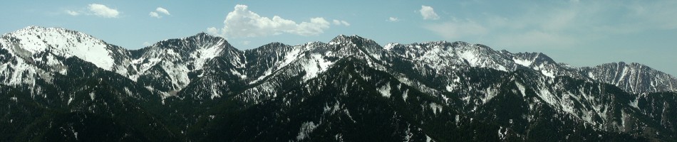
This mass of snow-covered hill (on the left) in the photo below is called “Red Baldy,” if I’m not mistaken…and most of the snow was melted on this front surface by the time I was leaving the lake.

Another shot to help with scale, there are two people in the below photograph, right at the juncture where the trail curves slightly back to the left near the bottom edge….

The water-level appears to be somewhere between 20 and 25 feet below the water-mark on the side of the basin. I haven’t included it in this post, but I have a photograph of a man standing on the shore and the line of the water- mark seems to be about four times higher than he is tall.

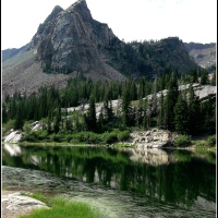
Even though the water is much lower, it still provides a beautiful reflection….

I spent a couple of hours searching for anything that could shed some light on the history of the dam, but could only find one very brief reference to it being built in 1920…and then nothing else. The topic isn’t covered in Keller’s book, as it intentionally details the history of the three-canyon area only up to the first decade or so of the 1900’s. Where he does step further into the next century, it appears to be auxiliary information related to the culmination or end-points of topics that have been covered extensively.

Just out of frame at the bottom right-hand corner of the below photo is the grate that covers the exit portal/drain in the wall of the dam. The water-level appears to be just below the bottom edge of the drain…so I don’t know if the water had been released from the lake, or if it was truly that low because of the much lighter snowfall this past winter. I’ve shared photographs of other lakes with greatly diminished water-levels this year, including The Great Salt Lake…so I’d guess that this one is lower for the same reason.

This last photograph is from my post White Pine Lake in September from 2011. You can see by this photo that the water-level was much higher at the time. If you’d like to see more images of the lake from that earlier visit, simply click on the highlighted name to follow the link back to the post. The difference in the lake’s appearance between the two years is incredible.

Please watch for a following post titled, “White Pine Lake Reflections”…coming soon….


Fabulous pictures Scott and an interesting narrative. The scale of these pictures is difficult to take in. Incredible landscape. 🙂
November 12, 2012 at 9:22 am
I’m glad you enjoyed it all, Chillbrook…thank you. And yes, there is something about the scale, too…those tiny humans seem to really accentuate the enormousness of the place….
November 13, 2012 at 7:46 am
Always love to see your pictures, what a beautiful landscape. We don’t have mountains in Holland 😉
November 12, 2012 at 9:26 am
Thank you, Yvonne…it’s nice to be able to share my corner of the world….
November 13, 2012 at 7:47 am
Again some great landcape shots Scott – you can almost smell the cold fresh mountain air!
November 12, 2012 at 1:02 pm
Thanks, Adrian…it was rather fresh and crisp out there!
November 13, 2012 at 7:47 am
Real snow! It really still actually exists! Thanks again for all the wonderful scenic beauty. I always see the world through different eyes every time I see your photos.
November 12, 2012 at 4:33 pm
Yes, it really does, Steven…and this was only a couple of inches. I’ve read that these mountains received another 3-4 feet over the past few days. I’m glad you enjoy visiting, Steven…thank you for being here with me.
November 13, 2012 at 7:49 am
Stunning photos and beautiful landscape. I don’t know how you ever leave it to go home (after your hike).
November 12, 2012 at 4:48 pm
Thank you, Victoria…and there is usually a bit of wistfulness upon leaving…and eagerness, always, to get back out there.
November 13, 2012 at 7:51 am
The scale of your magnificent mountains doesn’t make it easy to locate all those tiny specs that are fellow climbers. It’s easy to understand how you can feel so drawn to these peaks.
November 12, 2012 at 4:50 pm
It is so wonderful to be out there, Gunta…out in the middle of all of that ginormousness…. 🙂
November 13, 2012 at 7:52 am
I would think, if you live in a desert, that seeing the water levels of these lakes so much lower would be cause for concern.
November 12, 2012 at 4:52 pm
There has been some concern, Allen, but nothing scary yet….
November 13, 2012 at 7:54 am
This looks like a magical place dusted with snow.
November 12, 2012 at 5:01 pm
Very much so, Andy…thank you.
November 13, 2012 at 7:55 am
Thanks for the trip to White Pine Lake. A beautiful place. I enjoyed this post.
November 12, 2012 at 8:37 pm
I’m glad you enjoyed it, Scamps…thank you for visiting. 🙂
November 13, 2012 at 7:55 am
I love these photos!
November 12, 2012 at 10:16 pm
I’m glad you do, Terry…thank you. 🙂
November 13, 2012 at 7:56 am
The beautiful dusting of snow really adds to the atmosphere. It surely looks to have been well worth the hike. And the difference in water levels is really amazing.
November 13, 2012 at 8:55 pm
This was 3-4 days after the snowfall and about 1-2 inches remained on the ground up here in the more shaded areas. I had only made the trip once before, but still found it to be one of my favorite hikes, Gary…and yes, such a striking difference in water levels. I hope we have a substantial snowfall this season to get those back to “normal.”
November 15, 2012 at 8:09 am
What is it about snow that changes a landscape so dramatically? I love this series of landscapes and the scale is breathtaking!
November 14, 2012 at 1:37 pm
I’m not sure, Finn…but the difference is remarkable, isn’t it? I’m glad you enjoyed the photos…thank you. 🙂
November 15, 2012 at 8:09 am
Just came across this page. Love it. The dam was built and is still maintained and operated by a local water company called South Despain Ditch Company. The road as well.
March 15, 2015 at 11:44 pm
Thank you, Drew…I appreciate the information….fills in the blanks, so to speak.
March 16, 2015 at 7:35 am