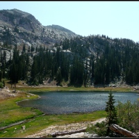
Bells Canyon Upper Reservoir
I have not been able to learn much about the history of Bells Canyon and its reservoirs, lower and upper. The canyon is not even listed in the index of the book, The Lady in the Ore Bucket, that details the history of logging, mining, and hydro-electric efforts in the three Wasatch Mountain canyons that border metropolitan Salt Lake City, Utah, USA. There’s probably a good reason for that, too, given that this canyon is south of the most southern of those three canyons, Little Cottonwood, and does not connect to it by any means.
What I do know, however, is that the lower reservoir is only a 15-20 minute hike from the trailhead…and it takes right around five hours to reach this upper reservoir. The trail is somewhere between four and five miles in length and gains right around 4,000 feet in elevation from start to finish.
I only recently discovered (on-line, before making the hike) that there was a dam at the upper reservoir…and even more recently (after arriving at the lake), learned that this dam has also been breached, similar to the dams at the Sister Lakes in Big Cottonwood Canyon. Construction and modification of those dams occurred between 1908-1934 and they were breached in 1972. While conducting a little more research for this post, I did find a digitized picture of the dam being built in 1914…and I’m still looking for more….
If the Bells Canyon reservoirs were built for the same reasons that the Sister Lakes were dammed, it was so that the water from the snow-melt could be held until it was needed for irrigation and other purposes later in the year when the mountain streams were running low.
I made this hike a couple of weeks ago by myself, but on this particular occasion, Son #3 was able to join me and helped provide some perspective for the scenery in the photographs.
My son is right about six feet tall…which means that the water lines on those two trees are about 10-12 feet above the ground…which means that the water in this lake has been significantly deeper than it was on the day of our visit.
Above is another shot provided for perspective’s sake…there’s a man next to the boulder in the lower right corner of the picture….
And below is a last photo provided specifically for perspective, there are two figures sitting on the left side of the opening in the damn. I shot this one from the mountainside on the opposite side of the lake, so it may lose a bit of its resolution if you attempt to zoom-in too closely on the figures.
The below photograph shows a much wider perspective of the northward view, taken from the same location.
And you’ve seen me before….
This was the last view of the lake before we rounded the bend in the trail, dropped down behind the retaining wall of the dam, and could no longer see it….


‘Tis one hell of a hike, but so worth every stride. Wonderful pictures, Dad 🙂
September 6, 2012 at 7:16 am
Yes, it was Nathan…and thank you. 🙂
September 6, 2012 at 8:17 pm
I’d love to explore that place. Your local Historical Society could probably tell you everything you want to know about it. I use ours every now and then and have always found the information I was looking for.
September 6, 2012 at 7:21 am
It would be fun to go exploring up there, Allen…I think we’d need to do at least one over-night in order to do it well, though. That’s a good idea about the Historical Society, too. I did browse their site a little bit after first reading your comment this morning and didn’t find anything that mentioned this particular canyon…but I will be looking further. Thank you for the suggestion.
September 6, 2012 at 8:19 pm
At the historical society, there will quite likely be an old-timer who loves to share, but may not be center-stage. Perhaps if you (cheekily) asked? >:-D
September 7, 2012 at 9:00 am
Thank you, Laghitana…such a character would make it an interesting visit. 🙂
September 12, 2012 at 8:04 am
Very nice. I like the inclusion of bipedal life forms for scale.
September 6, 2012 at 8:52 am
Thank you, Emilio…and yes, those bipedal life forms did enhance the understanding of scale for some of the pics.
September 6, 2012 at 8:20 pm
Very nice indeed Scott. 🙂
September 6, 2012 at 11:54 am
Thank you, Chillbrook. 🙂
September 6, 2012 at 8:21 pm
Scot. Once again, you include us in your adventures. Thanks a lot for this lovely trip.
September 6, 2012 at 12:16 pm
You are most welcome, Pattu…I’m glad you could go along with me. 🙂
September 6, 2012 at 8:21 pm
Yet another beautiful place, Scott, apparently well worth the hike, and how nice that you were able to do it with your strapping son! Just curious–what is the object sticking up out of the water toward the center of the reservoir?
September 6, 2012 at 1:19 pm
Yes, it is another beautiful place, Gary…and well worth the effort in getting there. And yes, it’s always nice when my sons can join me out there…it’s part of the reward in going, watching them marvel and all of that natural wonderfulness around us. 🙂
As best I could tell from the shore, that object in the near center of the reservoir looked like another tree stump, although that would be an odd place for one to be…. I know they built, or were building the dam in 1914, but I don’t know if the area was in lake-form before the dam was built…and if there wasn’t a body of water up there at the time, I wonder if a tree stump would still be there in the middle of the water for almost 100 years.
September 6, 2012 at 8:34 pm
A beautiful spot, Scott. Figures certainly do provide a sense of perspective.
September 6, 2012 at 1:24 pm
Thank you, Andy…and yes, they certainly do. 🙂
September 6, 2012 at 8:34 pm
Looks like another wonderful hike and thanks for the bipedal life forms (as Emilio put it). It’s so great you had a mighty perfect day in your beloved mountains – best of all, shared them with us. These posts are like a breath of mountain air.
September 6, 2012 at 2:16 pm
It was wonderful, Gunta…and you’re welcome for the bipedal life forms. It was nice that one of them could be my son, too. When I had made the first hike up there two weeks earlier, there were two other people who appeared for a while and then disappeared when I was admiring the scenery away from them, but I did manage to get them in a couple of shots. It worked well in having my son stand where I wanted him to, this time, instead of hoping to capture the others at a particular desired location. And yes, I get to share them with all of you, too…and relive the marvel of being there with your words. I’m happy that you enjoy the photos…. 🙂
September 6, 2012 at 8:41 pm
Thanks for sharing, Scott. Beautiful photos and looks like a fantastic hike.
September 6, 2012 at 2:24 pm
You’re very welcome, Erica…thank you for visiting and enjoying the post. 🙂
September 6, 2012 at 8:43 pm
It’s great to come hiking with you Scott, into your world. A world that you so obviously love. Thanks…….and do you know, it’s our therapy, as well as yours…………the only trouble is……..we don’t get the exercise…………. five hours, you say…….hmmm…….it makes me tired thinking about it..
September 6, 2012 at 3:51 pm
I’m glad you could join me, John…even if it was only through the photographs. It’s truly a pleasure sharing my little corner of the world with you and our other friends here. And yes, it was five hours to get there…and three hours to get back to the truck afterwards…a very long day of hiking…very tiring…and very well worth the aching knees and legs the following day. I’ve been up there twice now, John…and the next day after each hike, images from along the trail and around the lake would come to my mind on their own throughout the day. I would just be sitting there at work, actually occupied with working, and I would suddenly see a particular scene in my mind…. I loved it…..
September 6, 2012 at 8:51 pm
What a beautiful place and you captured it very nice 😉
September 7, 2012 at 3:50 am
Thank you, Yvonne. 🙂
September 12, 2012 at 8:01 am
The lake is really enchanting. A pleasure to look at such scenery. And very good that you provided us with a measuring rod (!) to appreciate the size of boulders and trees… how impressive.
September 9, 2012 at 8:43 pm
Enchanting, indeed, Shimon. I’m glad you enjoyed the “measuring rod” for perspective. Thank you. 🙂
September 12, 2012 at 8:02 am
Fascinating and beautiful!
September 11, 2012 at 9:35 pm
Thank you, Terry…it’s quite a place.
September 12, 2012 at 7:57 am
My great grandfather Lauritz Smith started work on the dam in upper bell in 1898; he used granite rock from the canyon and had the cement hauled up by horses. The reservoir was built to preserve water for farmers below.
July 26, 2016 at 8:54 pm
Thank you for the information, Jared…it’s always nice to have someone fill-in some of the missing details.
July 31, 2016 at 12:43 pm
Are there fish to catch here?
June 23, 2017 at 10:45 pm
I have seen trout in the stream several hundred yards downstream from the reservoir and have seen people hiking down from there with poles and tackle-boxes, but have never seen that anyone actually caught any up there…. The lower reservoir has “catch and release” signs on the trails around it, so I would guess that they stock the lower one, but can’t say for the upper one….
June 24, 2017 at 8:11 am