
Dog Lake…and Lakes Mary, Martha, and Catherine
These aren’t necessarily from the archives proper, but the photos are from a little while ago. August of last year found me visiting my Utah kids and then visiting the mountains and canyons south and east of Salt Lake City. You might remember that I lived there for a few years…a few years ago now…and that I spent most weekends hiking in those nearby Wasatch Mountains.

Of the many hikes that I took while living in Utah, I never went to the lakes that I am presenting in this post. They are situated in the conjoined space at the far eastern end of Big and Little Cottonwood Canyons. In fact, one can walk up to the lakes from the Big Cottonwood side, at the Brighton ski resort, and continue on the trail back down to the Alta ski resort in Little Cottonwood Canyon, or vice versa.

I didn’t visit the lakes for the precise reason that I described above…their proximity to potentially great quantities of people. To give a small example of how many people one might encounter there, let me say that there were five vehicles, including mine, when I arrived in the parking lot at 5:55 am, and over 50 when I returned to my truck at 10:30 am…and that was on a Monday morning in the middle of summer. When I lived there, I hiked on weekend mornings…so I avoided the place…in hopes of avoiding the above mentioned “great quantities of people.”

I didn’t study a map of the mountains before leaving for the hike, so I was a little surprised that I would encounter Dog Lake on the near approach to Lake Mary. The little body of water in the second photo is Dog Lake. There is another Dog Lake in Millcreek Canyon, just north of Big Cottonwood Canyon…and back when I used to study my mountain map of the area, I knew of both of these Dog Lakes…but had forgotten about this one. You might remember a black and white rendition of the above photo….

The photo below is from the close approach to Lake Mary…just a little ways further into the mountains from Dog Lake. As you can see the concrete wall in this image, you can tell that this is actually a reservoir, not a true lake.

Not that it matters much, what we call it…especially when we get up to the mountain-reflecting body of water and look out over it….

I had a sense of being home again when I was out on the trail heading up to the lakes…off in the mountains…very few people around…the smells of mountain earth, forest, flowers, grasses, and maybe even the water…all of it flooding my head…rejuvenating the muscle-memories and the actual physical sense of “being” in those surroundings.

I would have to confess then, too, that my body also knew it was only visiting, that it had been existing in the desert at maybe 1,200 feet in elevation…and that it was now hiking from over 8,700 feet up to 9,200 feet…and I felt that difference in my lack of wind and the need to “pull over” every now and then to catch my breath…heart pounding as it was rejoicing….

You can see the top of the reservoir wall in the below image.

There were three or four people sitting around Lake Mary and their voices carried loudly over the water and in the thinner air, so I made my few photographs and then headed back up the trail…up a little further to Lake Martha.

The bluebells were in a huge clump, almost like a grove, actually, if that’s possible…a rather large swath of near boggy forest floor that was covered in great, dark green leaves of some familiar plant whose name I didn’t know…with pink sparks of Indian paintbrush…and then almost purple gray smudges of what became bluebells as I got closer.

Life in passing…in waiting…in anticipation….

Between Lakes Martha and Catherine, there is a something like a minor cirque on the south side of the trail…it rather resembled an amphitheater…an almost bowl-like depression in the ground like some huge something had reached down and scooped out a chunk of earth and then littered the ground with grass and wildflowers and pine cones and rock litter from the hills above….

I sat in the grass and flowers for several minutes with my elbows propped on my knees, making photo after photo of the flowers…with my head and heart lost in the present and the past and wanting to stay there…right there…for fucking ever.
Anyway….

The bowl of Lake Catherine from the left…

…the middle…

…and the right….

This little guy has a bite of my chocolate brownie Cliff’s bar in his hands….

Now heading away from the lake…

Encountering another little squirrel-person eating what he’s supposed to eat…and appearing more fit and trim for doing so….

Lake Mary from above….

Yes…my favorite flower, ever…the Colorado Columbine in its various opening stages.

Below…red, white, and blue Wasatch Mountain wildflowers.

And the trail back down from Lake Mary with its patch of near hedge-like accompaniment of yellow flowers…and the forest beyond….

Thank you for enduring the longer post…for going home again with me to my beloved Wasatch Mountains…even if it was only for a few minutes. If you enjoyed the hike even half as much as I did, I know you absolutely loved it.
Wasatch Mountain Wildflowers
Images of this nature used to be the normal fare for my spring and summer weekend hiking when I lived in Salt Lake City a few years ago…they were common enough punctuation marks in the trip narratives…highlights of color in the mountain landscapes…

…and now they are very occasional and intentional shared treasures of uncommon forays back into that used-to-be.

I don’t know the names of all of them, but when I do, I will share them, as I will here, above, with Queen Anne’s Lace, or Cow Parsnip…

…and the predominant flowers in the above image being Horsemint…a name shared with me by a fellow hiker after a chance encounter and then a follow-on comment on a post in those years ago.

Western Coneflowers above, something that I have also seen in the higher desert meadows of the Coconino National Forest just south of Flagstaff, Arizona.

The above resembles a type of gentian I have seen before, but I’m not sure how it is properly named.

A perfect Monday morning horizon above….

A trial for the newer camera…not entirely crispy, but still very clearly capturing dew drops on petals and leaves.

A richness of color for the eyes and morning crispness for the skin…and the mountain aroma of wet grasses and fragrant flowers….

I’m not sure about these, but there were tons of them on a western-facing slope as the sun was just over the mountains on the eastern side of the meadow….

Closer above and below….

And this one might be my favorite of the entire day…dew drops on Bluebells and leaves…I can still feel being there, making this particular photo, with anticipation and hope at what I would see on the computer when I brought the image home.

Life is full in that mountain environment, a feast for the senses at every turn.

And as I’ve shared previously, the Colorado Columbine, below, is my favorite flower, ever.

These were a first for me, the little purple Dr. Seuss flowers below….

And a fitting end for the post, I believe: a carpet of wildflowers with a Wasatch Mountain backdrop….

All images were made on 8-12-2019 during my very first hike from Brighton up to and from Lake Catherine.
Antelope Island at Sunrise – Part Second
…continued.
There was simply too much to see, too many sights that demanded attention, contemplation, worship…and photographs.

My kids who still live in Salt Lake City had told me about the record snowfall for the past winter and spring; I had also read about it on one of the social media sites from the area that I follow.

I guess I expected that some of the earlier season’s snowmelt would have made it to The Great Salt Lake and would have raised the water level a bit…would have raised it “any” amount, actually.

There was water, of course, mostly north of the causeway from my vantage point, enough to provide those morning reflections that are inspiring in and of themselves…

…and enough, too, to afford the many waterfowl a place to forage, play, rest, and provide still other morning reflections that cause occasional human observers to stop along their various ways to attend, contemplate, worship…and photograph.

Also striking were the morning’s colors…the peachy orangish pink of the waking sky, shining of themselves above, and in the myriad reflections below…

…the black, dark purple, blue and gray of the lake’s living water…

…and the sage, green, rust, and straw colors of the waterside vegetation.

Cast all of those, too, among the brightening gold and greens of the covered hillsides and coves…

…the yellow faces and bonnets of the solitary individuals and masses of sunflowers…

…and finally the rich blacks and browns of the wandering bison.

It was a feast for my desert dwelling eyes.
mountain home
while in the salt lake valley for the family event and celebration that I mentioned in the last post, i found myself standing in a restaurant parking lot with camera facing east

i heard a young female voice to my left saying “excuse me sir…what are you taking a picture of…?

“is there a bird up there on a lamp post or something…?”

“i’m taking pictures of the mountains,” i said, “aren’t they beautiful?!”
her response….”you must not be from around here”

Twin Peaks from Dimple Dell Trail
It’s a sad song, but it struck me the other day that I have now been back in Arizona for longer than I had lived in Utah….and this little gem of a photo has been sitting in my “drafts” folder for over five years. This particular day in March of 2013 found me walking the neighborhood trail called, “Dimple Dell,” and gazing eastward at the beautiful mass of rock and earth known generally as the Wasatch Mountains and specifically as Broads Fork Twin Peaks (only the western peak is visible; it’s the one on the right). I had posted other images from the hike…maybe even some that looked very similar to this one…which probably explains why it was sitting in the “drafts” folder for so long.
Anyway, they are always bittersweet and tender moments when I look back and reflect upon what used to be in my backyard…at what was just a few minutes’ driving time from the house. And there it is….

Heading North Again….
Another glimpse of the locale from my trip north in June of this year….

Some of the images may look familiar, as I have already posted similar photos taken from different perspectives.

I will be heading back in a few days…a gift from my children…bringing me to the mountains…since they can’t come to me.

Fall in the Wasatch Mountains is awaiting…

…like granddaughters’ arms…to embrace me.
Lake Blanche in June…reprise….
The parking lot was already mostly full when my son and I arrived at the trailhead, but that was okay, as we/I prefer to park just off the road in the canyon…it’s easier to leave that way…hours later when the hordes of people are milling about with their comings and goings…. Aside from simply driving up into the canyon, one of the first wonderful things about this particular trail is the bridge crossing over the Big Cottonwood Canyon stream. Whatever the month or season of the year, it’s an almost magical, soul-moving experience to stand on the bridge or next to the rushing stream, watching the water make its way down-canyon. This photo shows the crush of the snow-melt…those billions of flakes that have returned to their primal form, filtered through the mountain’s soils and rocks and the vegetation’s roots…and now come at last to the stream-bed where they will be carried away and out into the city below.
Can you hear it…the rushing liquid surge that sounds like a a storm of wind in the high trees…can you feel the chilled air rushing with it down the canyon and into your face…enveloping your body…marveling your mind…soothing your soul…?

It had been more than three years since I had hiked this path, and being honest with myself, I had forgotten how steep the trail was at times…had forgotten how the faces looked of the people struggling up it as I had come down it on my many returns over the years…. It was the roughest hike I had made in quite some time…and one that didn’t use to be such a challenge.

Wonderful life in its simpler forms…the magic of a coming transformation found along the trail.

We’re not there yet, but this is one of the first glimpses of Sundial Peak as viewed from down the canyon…with the brilliant greens of the new summer growth, the patches of snow still extant on the east-facing slopes of the surrounding mountains, and the white trail of the stream that I know is running in its fullness as it drains from Lake Lillian.

Still on the approach, we can see Dromedary Peak to the right and the “Play Doh” like red rock in the foreground whose surfaces were smoothed by the passing of ancient glaciers many millions of years ago….

Looking over those smooth red rocks and back down the canyon in the photo below.

Getting even closer now, preparing for the final ascent up to the flat land before the lake…with a couple of hikers for near perspective.

I never made it up to the top of Sundial Peak during my years of living in the Salt Lake valley, but it was always something I wanted to do…something that I thought I would get to do on some weekend jaunt up there when those mountains were in my every-day…when they were a steadfast part of my eastward view.

The clouds were alive and moving with the strong breezes and winds that blew through our morning up at the lakes…constantly causing shadows to move over the water and mountain peaks….

Below is the view further to the west of the above images…where we can see the breached dam a the far end of Lake Blanche…

…and we know that the water continues down to Lake Florence and Lake Lillian…seen below in their descending order…stair-steps of cascading wonder….

We didn’t have sufficient time to explore for hours and hours like we did the first time my son and I made the trip up here in 2011…but the reward at the end of our hike up there was rich enough in itself to have made the entire effort worthwhile.

Lake Blanche and Sundial Peak in memory form.
Thank you for being here….
A Glimpse at Bells Canyon’s Upper Falls
After my daughter and I hiked to the lower falls, as featured in this post, we continued up the trail for about another hour and then arrived at the upper falls. Amid the spray and the treacherous footing on the soaked boulders and ground, it was difficult to manage another angle that would have provided a better or more clear perspective or presentation of this natural water-feature.

We stood in literal awe for several minutes, shifted our positions to gain different perspectives, stayed there again for several more minutes, and then retreated a bit into the woods that we had just come through to approach the falls.

You can still see the falling water through the trees to the right and behind my daughter in the above photo, so you can probably imagine how loud it must have been to be so close. There was a pervasive serenity, sitting there in the woods, even with the roaring of the falls as near as they were…with the crashing water on the granite boulders and then the rushing of the stream in front of us….

White patches up in the trees caught my eye….

What a refreshing spray after the steep hike to get there…melted snow…living water….

Just a little further downstream is a bridge that has been chained to the trees on both sides of the bank to prevent the rising and rushing stream from carrying it away. There is a trail that you can take off into the shoulder-high brush that will lead you in a near circular manner out and up to the area just upstream from the top of the falls…and will also eventually lead you to the upper reservoir and beyond.
If you’d like to see an image of the falls later in the season, you can click here to see what they looked like in August of 2013.
Bells Canyon Reservoir and Lower Falls
I have stood in this exact same spot, on a bench mind you, overlooking the Bells Canyon lower reservoir so many times that I cannot begin to number them from memory.

…and I have walked this trail in all seasons, heading toward the lower and upper falls, and even toward the upper reservoir another couple of miles up into the mountains.

If you look closely, in the above and below photographs, you can see a tiny splash of white that is brighter than the rocks below and to the left of it…that white splash is what I perceive to be the lower falls…something that I have observed from several miles down the road, and even as far away as the back balcony of my children’s home in West Jordan on the other side of the Salt Lake Valley. Some might suggest that it is the upper falls, but there are no singular monstrous rocks beneath the upper ones, only the lower ones, where I and my hiking companion sons have rested and snacked after admiring the falls face to face.

Below is a favorite spot along the Bells Canyon stream…another special place that I have photographed multiple times…with snow on the banks and perched like cones or caps on top of the rocks with the water barely trickling among them, or with the rich greens of spring and summer when the water was crashing or running over the tiers of rocks like a flood.

It’s always such a pleasure to stand back and watch as someone beholds the falls for the first time…to see the delight in their eyes, and to watch the slight grin grow into a full-on smile as they are slowly christened with the over-spray and mist….

My daughter shared with me that someone had slipped into the falls a couple of weeks earlier while attempting to jump over the stream that led into them…and of the near futile efforts to locate and recover the body from under the logs where it was eventually found…a rescuer saw a flash of color in the crush of water that didn’t belong in the middle of it all…the red or yellow or blue jacket that was still on the the body….

In the last 100 yards or so climbing up to the falls, more than 30 hikers passed us on their way down the trail…and fortunately, there was only one other person up there when my daughter and I arrived…another quiet individual who we only glimpsed once or twice as we cherished the amazing wonderfulness that surrounded us.

The above photo is from near the spot above the falls where the individual likely attempted to jump across the stream. I have sat there in the past with at least one of my sons…admiring the view and the crush of the melted snow that thundered over the falls…while having a snack of a crisp apple and “Indulgent” trail mix.

My daughter and I continued up the trail to the upper falls (to be shared in a later post)…but this is what it looked like, in the above photo, facing back up the canyon on our return trip down to the reservoir….

And lastly, an afternoon view of the Bells Canyon lower reservoir…. It used to take me 15 minutes to drive to the trailhead for the trail that leads to the reservoir…now it takes more than 10 hours….
Sundial Peak and Lake Blanche….
One could probably say that I’ve been guilty of overdoing things with my posts on Lake Blanche and Sundial Peak, so I’ll keep this one to a bare minimum and only post one photo from my most recent trip…although it’s been more than three years since I have been able to make the hike up there, so I should probably lay it on thick and post something like 20 or more photos…. Anyway, here’s the postcard image with the little people included so you can appreciate the grandness of the place….

If you’re relatively new to the blog, you can start here in viewing other posts on the lake and it’s surrounding area…or you can scroll down a little bit past this post, find the “Search” widgit, and enter “Lake Blanche” or “Sundial Peak” into that feature to be presented with a veritable list of options for seeing more of the place.
Mountains, clouds, and fence-line…
The Wasatch Mountains as viewed from outside of the Cougar Park Nature Preserve, West Jordan, Utah…close to an acre of undeveloped land that has been allowed to remain in its natural state…and which happens to be the home of burrowing owls. Humans are invited to visit the preserve and follow the meandering trail…but only during the months of October through February….

Mt Raymond from the trail to Lake Desolation
Another visit to the archives brings this image from a hike I took on the Sunday before Thanksgiving two years ago. Exactly four weeks prior to this day, I was sitting atop that summit in the distance, Mt. Raymond, admiring the view of the canyons and mountains around me…360 degrees of wonderfulness…and a fantastic experience rivaled by few others….

Late Fall Canopy
An image from another time and place, sitting in the draft folder for nearly two years…it holds memories that are fresh with a crisp mountain air that rides with the iron smell of a coming snow…the sound of booted footsteps on a narrow trail…and a companion named “Solitude.”

Desolation Trail Memories
I can’t assume that it’s a body memory, as my body only made this particular venture once, exactly two years ago this weekend, although I had been on various parts of the trail several times over the years, but this occasion, this hike, has been floating around in my mind for the past few weeks and I decided to take a look at the photos again. I won’t present an entire gallery or series of images as I did after taking the hike, but I will share a couple of photographs that I find to be particularly appealing and representative of the beauty of the region.

The above image is but a fragment of what must have been acres and acres of wildflowers that were covering the south and western facing slope of Mount Raymond. When I was sitting in the saddle of the mountains in the below image, the deeper cup shaped spot to the left of the highest points (the Twin Peaks), one week later, I could still visualize the yellow blanket of wonderfulness that I was standing beside as I made these two photos…even though I was probably six or more miles away.

Thank you for visiting and sharing some sweet memories with me….
Favorite images of Little Cottonwood Canyon…for a friend….
It’s been almost a full year since I drove away from the Salt Lake City area to return to my former and current home in Phoenix, Arizona. During this year, I have longed for a return to “my mountains” and the canyons and trails that occupied so many of my weekends when I lived there….and while I haven’t actually made the drive or taken a flight to make it back up there yet, I have visited it often in my mind and through the medium of the hundreds and thousands of images that I made while I was there.
I just made a rough count of my photo library, and if it’s anywhere near correct, I went on hikes or exploratory excursions into the Wasatch Mountains at least 140 times during my 3.75 years of living in the Salt Lake area. I forgot (I don’t know how!!) my camera on one occasion, but it was with me on the other 99.21% of those hikes. And, of those 140 ventures into the mountains and canyons in my “back-yard,” I visited Little Cottonwood Canyon at least 27 times…sometimes hiking only the first half, other times just the second half, sometimes hiking to a specific spot on the winter stream to capture images of the magical ice patterns and formations, and on other occasions hiking from one end to the other and then exploring further into the area beyond what was considered part of the formal trail…further away from the tracks and traces of people, into what we might consider the “wilderness,” both figuratively and literally, as certain areas of this section of the Wasatch Mountains had been designated official Wilderness Areas by the federal government.


The western-most trail-head to Little Cottonwood Trail is located at the eastern-most end of the parking-lot for the Temple Quarry nature trail….and it was roughly a 15 minute drive from my home…. I visited the canyon during all seasons, as you can see from the three galleries…Spring and Summer in the first, Fall in the second, and magical Winter in the third.
Having lived in the urban desert of Arizona for more than 20 years before moving to Utah, it was amazing and wonderful to my mountain-loving soul to find myself is such an environment…every vista made my heart soar…and near every glance around made me want to capture its image for safekeeping against a day when I might not be able to view it again. And…it was a thrill to bring those photographs back home and look at them again on the computer…and then share them with you here on the blog….so you might recognize some, or many of these images.


And finally, the beauty and magic of Winter in the Wasatch Mountains…Little Cottonwood Canyon viewed from afar and from very close. While it was often incredibly cold, I enjoyed being out and in the canyon at this time of year. It was so captivating visually, that even with freezing fingers, I stayed out there for several hours at a time, slowly walking the trail, perching precariously over the ice-cold stream, and climbing over boulders in the forest and in some portions of the winter dry stream-bed (most of the water being captured upstream to be piped into town for drinking water).


While this post is for everyone to enjoy, I brought these images together specifically for one of my dear blog friends, George Weaver, at She Kept a Parrot and The Fuzzy Foto. Ever since George and I stumbled across each other’s blogs, shortly after I moved to Utah almost five years ago, she has been a constant blog companion, following me on hikes through the mountains and canyons, and admiring the treasures of photos that I brought home to share. At first, she said the mountains looked fearsome, but she came to love them and looked forward to seeing them week after week. George came to especially enjoy Little Cottonwood Canyon…and we have agreed that if we were ever to meet in the Hereafter, it was going to be on the trail in this little piece of mountain heaven.
Thank you for your encouragement and companionship, George….sending you peaceful thoughts and a warm embrace.
Red Pine Lake reflections
Those are Broads Fork Twin Peaks behind the larger tree and just to the right of the center of the image…they are the highest peaks in the portion of the Wasatch Mountains that form the eastern geographic boundary of Salt Lake City, Utah, USA.

Fall…memories….
It was probably a Sunday, because it usually was…September 23 of two years ago…hiking in the mountains of Little Cottonwood Canyon, just south and east of Salt Lake City, Utah…the Wasatch Mountains in Fall. I would say that it feels like a lifetime ago…with so many changes since then, but it was in my life…then…consistently, richly…and now it is in memories only.

Bells Canyon Upper Falls
I made this photo in August of 2013 on what was my third trip to the upper reservoir in Bells Canyon, just south and east of Salt Lake City, Utah…it was also my last trip to these falls and the reservoir beyond…which I didn’t know at the time…couldn’t have known at the time…. But it is and was, and that’s the way it goes. You might know that I’m living in the desert of Arizona now, again, and scenes like the one in this image are far from my experience in this new and old home of mine…they might exist, I just haven’t found them yet.
And why did I post the photo today….I don’t know…maybe a hankering or longing to be on the Wasatch trails again…thinking about where I’d be going if I was there. Anyway, aside from the nostalgia, this image (even with the blown-out water) shows some of the damnably gorgeous scenery of the Utah mountains and canyons. Enjoy….

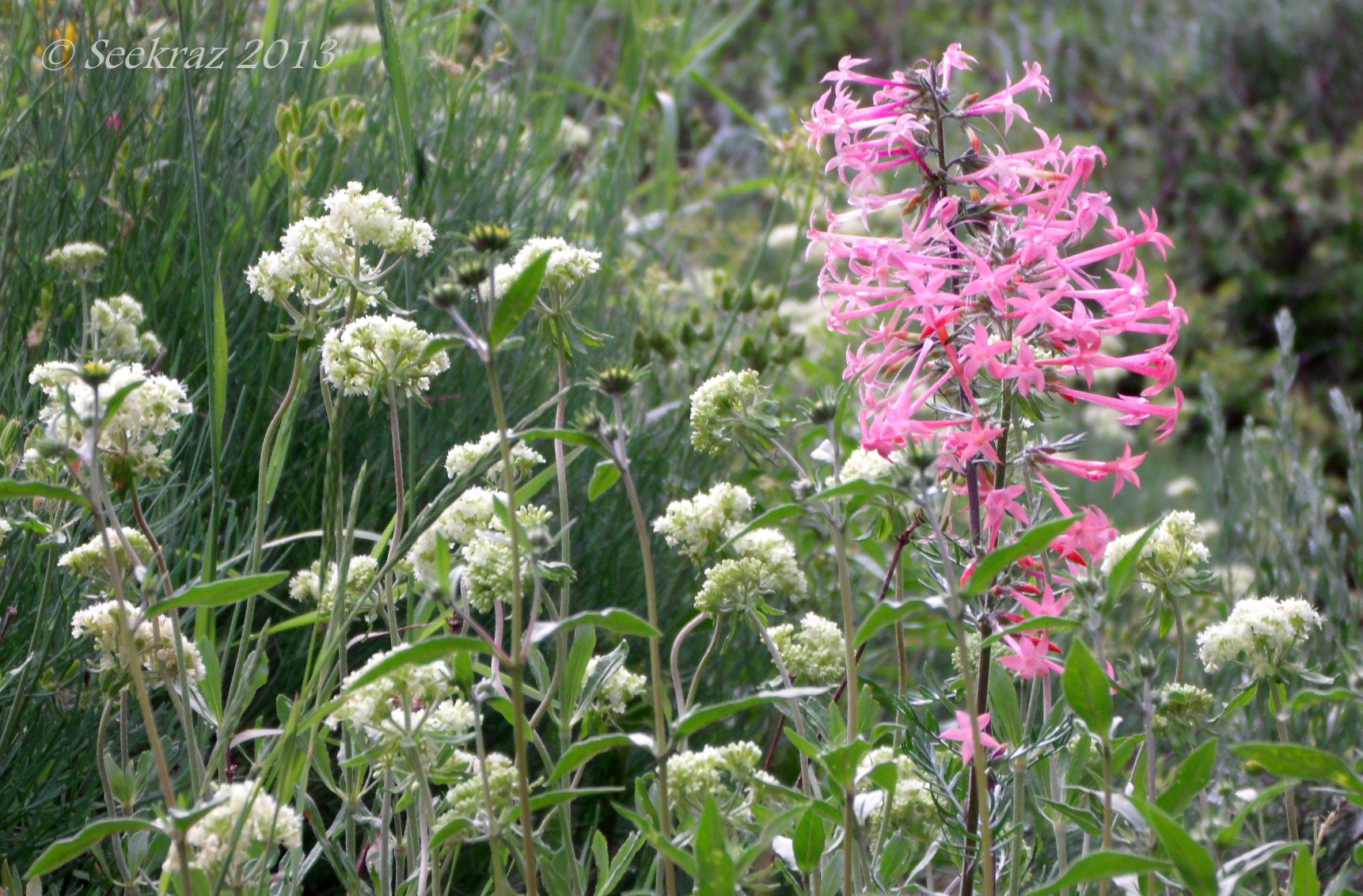
Pink Skyrockets?
I was visiting with Montucky at Montana Outdoors and noted that I had some images that were similar to his recently posted photographs of Skyrockets. I thought I remembered seeing some in white and pink, but could only find these in pink. They look like they could be the same flowers, but maybe they’re not…. If I’m not mistaken, the white flowers in this photo are Leafy Jacob’s Ladder.
I made this photograph in July of last year during a hike to Lake Desolation in Big Cottonwood Canyon of the Wasatch Mountains just south and east of Salt Lake City, Utah, USA.


calm
At 9,400 feet in elevation, this is under several feet of snow right now, but this is what Bells Canyon upper reservoir looked like in August, 2013. After a moderately strenuous, four-hour hike to reach the location, there is peace to be found along the shore of this desolate, alpine lake. While there is no snow on the Salt Lake Valley floor, it will be another few months before the trails are clear enough for me to make the venture this far up into the mountains…and I can’t wait…..


