a morning’s grace
I have wanted to stop for years…

…at least a dozen of them…

…the years…

…and finally did…

…after passing the fields countless times…

…I couldn’t resist…

…heading north again…

…across from Sunset Point…

…just before “Sunrise….”
Walkin’ Jim Trail and beyond….
The morning started with the alarm and coffee and then a neighborhood street that led to Bell Road, to the Sonoran Desert Parkway, to Lake Pleasant Parkway, to the Carefree Highway and west past Lake Pleasant, then to Castle Hot Springs Road, and finally, five miles north to a trail-head in a parking lot that has been re-fenced with silver wire that is new against the morning, untarnished and unvarnished with desert sun and windblown sand, unrusted in the elements, bright and confining, restricting of early hikers looking for familiar portals that ride now in memory alone.

Common and uncommon things mix in a November sunrise.

Somewhere between light enough and yet not enough…we see destinations unfolding with the trail…like the white caps on the tips of the many saguaros’ arms with their densely packed and unfolding new spines…things to come.

One of many crossings of Cottonwood Creek…a familiar place with wild burros, great horned owls, and collared peccaries….

and lying on the desert floor, looking east…and finding that “distant fairyland of wonder and bright alarm.”

A creosote frame leaving an aromatic resin on fingertips….

…and the tiny treasures of desert wildflowers….

Still heading west…with the destination in the upper right corner…after many winding turns, hills, valleys, dips, and desert meadows….

A distant spot of white in a green and brown world….

Zoom….

Gaining elevation and looking east…we can see a bit of Lake Pleasant tucked into the haze covered hills…

…and south…faint waves of them…green, purple, blue…white…and gone….

Higher now, more of the lake…and the landmark of Castle Hot Springs Road. You might remember that the haze is from California’s wild fires back in October/November.

The stark contrast of yellow against the greens and browns of the desert is a welcome change…it is even a surprise sometimes.

Walkin’ Jim Trail follows Cottonwood Creek up into the mountains, all the way from Castle Hot Springs Road…when the occasional mis-adventurer loses the trail on the way down the mountain, all he has to do is locate the proper drainage down from that mountain and follow it back into the stream-bed…and back to the parking lot where he started….

There were tadpoles larger than jellybeans in the pools along the way…more desert mysteries…marvels…Sonoran Desert surprises….
Badger Springs Trail
I’m quite certain that I’ve said it in the past, but I have another opportunity to confess, or admit, anyway, that I have become something of a reluctant admirer of Arizona’s desert beauty…the landscapes, rather, in which one might find beauty, might encounter the aesthetic appeal that touches whatever it is inside that gets “touched” and one knows or senses that one is in the presence or beholding something that one esteems in such places as beautiful, awesome, wonderful, inspiring, or even simply nice.

Water on the trail already and probably not more than a couple hundred yards from the trail-head.
My personal point or range of reference in such cases has been the landscapes of my childhood in Germany (with visits to France and Switzerland), South Carolina, and Florida, the high desert and mountains of the Front Range in Colorado in my younger adulthood, and more recently, the mountain and valley landscapes, as well as the winding river bottoms and grassy plains of Utah, in what I am hoping is still my middle adulthood.

At the crossroads, looking west. Two small figures at their campsite. I chose to go the other direction.
While it might not be fair, proper, or even emotionally healthy to make comparisons between places, preferring to live in one over the other, for instance, one cannot help notice differences between and among them, some of which one simply happens to enjoy more or less than others. One friend suggested that there is no need to like one over the other, or even prefer to live in one over the other; he said that I should simply enjoy them for what I find in their offerings, for their individual appeal to that internalized aesthetic that makes my heart say, “Oh….”

Heading east now, preparing to meet the morning’s sun.
I haven’t been hiking for several months now…not since last August, actually; there have been reasons, not excuses. That said, I went hiking the other day, and found reasons, again, to reluctantly admire the Arizona desert that lies something like 60 miles north and east of my home in the extreme northwest corner of the Phoenix metropolitan area.

A quick look back in the direction I didn’t go, with a nice view of a brimming pool of desert water.
I have read trip narratives and other on-line literature about Badger Springs Trail many times over the past few years. I knew it wasn’t a very long hike and knew that it wasn’t too terribly far away, either, so it made for a good starting place to get back into the desert hiking thing.

And now into the sun…looking up the stream-bed with its bouldered bottom.
The trail is situated in the Agua Fria National Monument, something like a preserve, but sketched throughout with dirt roads that allow for vehicle travel to access its deeper parts.

Another pool in the sun’s glare. I was surprised at how much water was actually there.
If you remember the post I did a couple of years ago on “Indian Mesa,” that area is also contained within the Monument…several miles distant, but still there. Some of the trip reports have indicated that there was no water present and definitely no badgers present; other narratives have said that there was plenty of water, depending on the time of year, but still no badgers. My hopes, when leaving the city, driving up the freeway and out into the Monument, were only that I would be away from people, computers, and the noise of society. While I did momentarily encounter two very distant people on my way out, and only two handfuls of them on the return trip, I did not come across any computers…or any noise of society.

Other people from other places…likely a Raccoon hand-print.
I did happen to see some ant-sized jet-liners making their way across the sky as I looked toward the various ridge-tops at a few points during the hike, but other than those few glimpses of people and airplanes, my hopes were realized and my soul was quieted upon the return drive to the city…something that I don’t remember feeling for quite some time…the peace that comes from having been immersed in an undemanding Nature that is simply there…even for a few toiling hours.

I left the trail earlier than I could have, but made the best of the boulder-strewn stream-bed.
When I had studied the landscape features of the Badger Springs area on Google’s map the night before the morning of the hike, I figured that I would follow the trail toward the right at the juncture, that I would head west and then south along and through the dried river bed. It appeared that one would have that option (and one really does, of course, it’s the wide-open desert, after-all). When I actually arrived at that juncture, the trail quietly suggested that I head the other direction, east and then eventually north.

Back on the trail proper for a bit with the morning’s low sun shining through last season’s dried grasses.
At the realized crossroads, I viewed the two people off in the distance at what I perceived to be their camping grounds, off to the right and west, a situation that I didn’t want to disturb or otherwise intrude upon…so I turned east and off into the morning’s sunrise. I followed the well-maintained trail until it reached the boulders of the stream-bed. At this point, I remembered that one of the narratives’ authors said it was best to cross to the other side and then continue on from there, evidently the boulder-hopping was going to get extreme, which it did.

Not fully leaved, the trees are still in their early springtime, but they have plenty of water to help fill in the new leaves.
There were many small and large pools of shallow water throughout the course of the stream; most would have soaked one’s feet and legs up to at least mid-calf…and very few others would go beyond that. The boulders were ancient granite that had fallen from the surrounding cliffs of millennia past, washed smooth by the floods and the fine sands they carried, polished and bleached unto a near white, some of them, in stark contrast to the brown of the watching hills; and chunks of lava, too, rich in their darkness, like porous, black bowling-ball sized oblique orbs tumbled from some distant cauldron.

The images don’t follow the narrative, exactly, but they are presented chronologically from the beginning and take us all the way to the turning-around point.
When I think about the name of this place, Badger Springs, I have to wonder at how long ago that last badger was seen, have to wonder at how common the creatures used to be at such a place, if they ever were, and I do not wonder at how important this place of water must have been, and remains, to the animals who lived and continue to live in the area. My mind goes also to the meaning of wild and how much of that remains in this place, how much of it remains outside of my wondering at what it must have been like, exactly there, before the Europeans came to see and stay, at how it must have looked when there were only the Native peoples who lived in the area and what their lives must have been like. My one disappointment with the hike is that I was not able to locate the petroglyphs that adorn scattered rocks in the area. When I read about the trail in the on-line literature, I thought it said they were at the end of the trail, near the top.

A very minor case of Badger Springs “reflectioning.”
Part of my wandering led me to be ever looking at what the end might be, what it could have been, what the top might be, as I was walking through a riparian wilderness that had existed for what must have been centuries upon centuries and longer, a remaining waterway that flowed through a rich canyon of scattered boulders, grassy meadows, and collections of cottonwood, sycamore, willow, and other deciduous trees and shrubs, and even juniper and thorny mesquite trees with assorted prickly pear and cholla cacti. The stream went on and on, there was no solitary source, no “spring” that I could find, just the seeping and flowing water that percolated down through the hills and up from the ground and then collected in the waterway’s bottom, as water will do; it flows with gravity and then through the earth when there is enough to collect, its drops and tiny rivulets gather, as they do, and start to move, below the surface of the land and then above it when it can, going where there is least resistance, through and around, living in and on the land and nourishing what it passes, bringing and sustaining life in an otherwise wasted land.

A more serious case of Badger Springs “reflectioning.” Don’t forget to look down when hiking.
The only actual animal that I saw during the hike, aside from a smattering of birds and a solitary unnamed lizard, was a black bull, an Angus, maybe, a calm mass of flesh and hair that was grazing alongside the water in grasses that reached near to his belly, a creature that left huge tracks in the mud, the corporeal sign of the one other heartbeat that was with mine out there that morning.

It took about two hours to get to the turn-around point, so much of the hike was in the shadows of the cliffs and hills on the south side of the stream. I had completed the four-hour hike and was back to my truck by 11:00 am.
Yes, I had seen tracks of other peoples’ passing, too, footprints large and small made by shoed humans coming and going, some moderately fresh, and some that were made several days ago; but other Peoples’ marks, too, tiny bird tracks, and dogs or coyotes, even, those familiar footprints from my lifetime made in their own coming and going, to and from the water, mostly without human people’s prints accompanying them, and then there were the pointed hoof marks of javelinas in a different location…and finally, a raccoon hand-print in the still wet mud near a pool, left when fishing, maybe, or simply just washing. What else has gone away with the badger…what cats, deer, or antelope did I not see, could not have been seen any longer…what other parts of the wilderness and its wild lives have passed and gone?

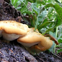
I’m not decided on what is the main object of the image…but wish the flowers had a little more light to bring out their detail
The proper trail was lost and gone at around the one-mile mark, give or take, so the rest of the trip was all in the actual bed of the stream, sometimes hopping boulder to boulder, but most often walking on the dry earth down through the waterway or on either bank. I must have crossed the bed half a dozen times when the growth became too thick to be reasonably passed-through, and sometimes I passed through the growth anyway, and have the bloodied scratches on arms and legs to prove it.

Another scene that is so incongruous with my idea of the desert.
I was watching for snakes and pack rats, Gila Monsters, and road-runners, and saw none of them; I was looking, too, for those petroglyphs, mentioned earlier, and couldn’t imagine where they might begin to be; at what possible place among the hundreds could I begin and have any chance of finding the proper one.

Another “reflectioning” image right before the 90 degree bend.
The stream bed hit a ninety-degree bend at about the mile and a half point; the terrain changed on both sides of the waterway and became more like rolling desert hills. They were populated with various bushes, including jojoba, creosote, and California bottle brush, as well as the different cacti mentioned earlier. The now-western hillside contained a bit of a lava or basalt parapet, but there were no “boulders” around it that I remembered from the photos I had seen on-line. I had hoped to have something distinctive to draw my eye on one of the hill or cliff tops indicating that they had previously been occupied areas, but nothing struck me as likely places, so I continued on, pushing through the scrub, wondering when it would be far enough.

In another part of my hiking life, I would have thought that black spot near the center of the photo was a moose….
At what I believe to be the two and a quarter mile mark of the hike, I stopped for a water and snack break in the middle of a stand of ancient cottonwood and sycamore trees. It has been sufficiently warm at night for the trees to waken from their winter slumbers, so they were all bedecked with fresh green leaves, full of the bright verdure that meant they hadn’t been baked and hardened by the summer’s sun. The ground in this resting spot was covered in sand that reminded me of an ocean’s beach, evidence of the mass and force of the typical monsoon floods that must frequent such a place. Rocks had been tumbled there, as well, and it has clearly been a while since any such floods had occurred, as there was plenty of typical tree litter that must have accumulated through the fall and winter seasons: branches and twigs, leaves of so many kinds, the fallen husks from the new leaf buds, as well as some kind of nut bodies from some unknown tree.

Poor guy had those seed pods stuck on his face. I had a bad enough time with them getting stuck in my socks and boot laces.
It was when I was here, in this cottonwood garden, that it was so quiet as to make me feel that my ears must have been plugged, somehow; the quiet was total, with not even a whispering of a breeze causing a tinkling among the cottonwoods’ leaves…a complete quiet…one rich in its fullness.

Just north and looking back at the stand of cottonwoods and other trees where I took a break and enjoyed the richness of quite.
That’s probably enough. I hope you’ve enjoyed this little jaunt along the Beaver Springs Trail of the Agua Fria National Monument in Yavapai County, Arizona. Thank you for your company.
Desert light….
By far, I have found it best to be on these desert trails shortly after sunrise, or within the first hour thereafter….

…the light is more pleasant and provides for greater character in the subjects found along the way.

Two Sundays ago found me hiking south on the Black Canyon Trail from the Bumble Bee trailhead. I have hiked this stretch of the trail once before…on a sweetly cloudy day in July of last year.

I didn’t go as far with this present hike, as the day’s heat was growing more oppressive and casting something of an ugly hue on everything that caught my eye.

I didn’t get out hiking in the earlier part of Spring, and have therefore missed the rich greenness that all of these wild grasses and flowers must have added to the area.

I love the pearl-like clusters of the creosote or grease-wood bushes…especially when the morning light is behind them.

The desert, overall, wasn’t especially attractive on this particular morning, but when I stopped along the trail to look more closely, I found plenty to admire.

All of these images are from the first two and a half hours heading out on the trail.

And in the photo below, a glance skyward brings a reminder of what can happen if one tarries too long…..

Sonora Desert Morning
…the trail rounds rocky corners and hiding hills and rises gently from the desert floor as the sun eases from below the far horizon and lights anew this sharp and prickly land…the glow and flare inside the lens is equaled among the red spines and golden stems of cacti and brush and grass alike…the morning fire quietly waking the harshly coated earth…sweet light fading soon with the ascent of day….


“Drinking Snake” segment of the Black Canyon Trail
I’ve shared several posts with images that I’ve made while hiking the Black Canyon Trail, here in the Arizona Sonora Desert, just north of Phoenix. If you’d like more information on the trail system itself, you can click on the highlighted name to be taken to the home-page. There are something like thirteen sections that cover approximately 78 miles of scenic desert trail leading from the Carefree Highway, just down the road from my house, all the way up to highway 69, just north of Mayer.
This post pertains to the area that I covered during my ninth hike on the Black Canyon Trail (BCT), the Drinking Snake segment, which, if you care to look at a map of roughly central Arizona, you will find six miles north and west of Interstate 17 and Bloody Basin Road (exit 259)…and for those further interested, or even mildly curious, I did not encounter either a drinking snake or a bloody basin….

I was still about three miles from the trailhead when I was compelled by the beautiful sky to stop and make some photographs. The above image is from 7:28 am., about 12 minutes before the one below, taken from the trailhead parking lot.

I can’t think of a reason to share a photo of my truck here on the blog, so just forget that it’s there. I always take a photo of the truck at the start and end of my hikes to mark the time…that’s all…and given where the sun is located in this particular image, I figured (when I made it) that the sun would wash-out the image, but it would still show the truck and mark the time. When I returned home and found that it was actually a rather nice image of the sun just peeking over the horizon, I had to do more with it than just leave it in the folder. Anyway….I was happy that my point-and-shoot captured an uncharacteristically clear and aesthetically pleasing image of the moment of sunrise at 7:40 am.

As you will notice as you scroll further into the post, and possibly remember or reflect on the desert images from earlier postings, the landscape I encountered on this hike was markedly different from what I found on other outings. The first example of that difference was in the juniper trees that appeared in clumps and in singular instances along the trail and out on the rolling hills and plains. The cairn above appeared to be a tabletop for some creature that thrives on the juniper berries. I found a handful of other locations along this first part of the trail that appeared to be similar feeding stations.

A reliable website that I frequent when researching various hikes, Arizona Hiking, indicates that the elevation of the Drinking Snake segment ranges between about 3,900 and 4,300 feet, which is a significant enough increase in elevation to effect the types and kinds of cactus and other desert/high-desert vegetation that can live there.

The weather report for the area said that it was going to be a partly to mostly cloudy day…but it was a bit different during the time I was out on the trail. There were beautiful clouds for sunrise and the next hour or two, but the earlier winds seemed to have removed them for mid-day and early afternoon.

I love to hike in the mornings…aside from there being many fewer people out hiking or riding their trail bikes, the rising sun plays wonderfully on the cactus spines and grasses that I normally find along the way.

The below photo is a bit darker than I would prefer, but it still gives you an idea of the grassland and the different type of shrubs…the singular yucca with its multi-podded antennae, the juniper off to the right, and, of course, the few groupings of the ubiquitous Prickly Pear cactus….and the fence….

And here are another five photos that show the morning light captured in the cactus spines and seed-heads…

…a different variety of the Prickly Pear cactus…and seed-heads…

…a nearly heart-shaped lobe of cactus…

…wild grasses and cactus spines…

…and some kind of wildflower left-overs among the cacti….

Looking toward the southwest, but mostly west, we can begin to see more of the Bradshaw Mountains…beyond the rising, grassy plain…

…and looking behind us, the direction from which we came, we can see the flatter grassland and those fading clouds….

A few minutes later, the trail turned a bit toward the east, still going south, though, so the mountains out in the beyond are not the Bradshaws…but possibly the New River Mountains…I’m not sure.

The online resources indicate that this watering hole and windmill are at 2.8 miles into the hike…but they didn’t say anything about the clatter and racket from the blades, or the sound of the wind in the air and among the grasses….

Those are the Bradshaw Mountains off in the distance…and I believe this little draw area in the foreground might be the drainage of Antelope Creek…. The section of the trail just south of this Drinking Snake segment is named after Antelope Creek…and this bit of landscape is in the right spot to be such a named thing….

And this next image is looking east again, with a bit of south in it, as well…with a couple of horses and mountain silhouettes, cacti…and the ever grasses….

…a bit closer….

…and a bit farther away, too, from a slightly higher elevation and further down the trail where you can see a greater spread of the land.

We’ve already seen a different presentation of this next image…it’s the same bit of ground as the one where the horses first appeared…but we’re closer now.

The Drinking Snake segment of the Black Canyon Trail actually ends right there at that lone tree in the upper image. Just beyond that spot is a graded road…Forest Road 259, or Antelope Creek Road….the northern starting place for that next section of the trail that I mentioned above. I’m not sure how long that stretch of the trail is, but it will join up with the segment that we visited a while earlier when we went north from Bumble Bee Road…back in July.
I made this last image toward the very end, actually the very middle, of my hike…my turning-around point. It’s about 0.8 miles into the next section of the trail that is south of the Drinking Snake segment. I hadn’t explored this bit of ground on the map before heading out…and hadn’t indicated (on the note I left taped to the fridge at home) that I was going further, so it was a good spot to sit and have a snack before heading back to the truck.

So…that was another almost six miles of the Black Canyon Trail…shown in chronological order from the starting sunrise to the point of return. Thank you for joining me on the hike. I hoped you enjoyed this latest glimpse of the Arizona Sonora Desert….

Black Canyon Trail north from Emery Henderson Trail-head
Sunday morning, November first of this present year, eight minutes into the hike…the desert looked like…well, the desert as I have come to know it. This stretch of the Sonora Desert has become rather familiar. I’ve been on this trail eight times now and have covered more than 40 of its 70-plus miles…and this stretch is the furthest south that I have been. There might be still one more track south of this trail-head, but being familiar with the area south of here, I doubt that I’ll head in that direction.

The early twists and turns of the trail, and the crossing and re-crossing of dry water-ways or creek-beds had brought me up a slight rise and pressed on toward a flatter plain that would soon give way to other and more declivities and inclines as I progressed northward. I had seen this particular Saguaro from further back and wondered if the trail would take me anywhere near it. If one were “looking for a sign” when lost out here in this desert wild, that someone might be tempted to view this as some kind of guide, or not…. I found it to be a significant landmark that, when coming from the other direction a few hours later, told me that I was very close to the end of my excursion.

I’ve seen mistletoe several times, but don’t know that I’ve ever posted any images of it. Here it is in it’s context…

…and here it is again, but in a closer view.

The living and the dead of the eternal desert….

An old-school trail marker, faded by severe summer suns….

The trail was actually quite a bit lower than the surrounding desert in the below photo. I thought it provided a nice shrub-height perspective.

I thought there would be more to this section of the trail than there actually was. I came to the end much sooner than I thought I would and then stood there mid-trail thinking, “Is that all…really?” It felt much too early to head back to the truck and I wasn’t inclined to marching further on the already familiar track, so I headed off-trail to explore a couple of the minor peaks in the area. After reaching the top of one, I turned north and found a pleasant-enough view of the desert beyond…the trail toward the middle of the image is the one that would take me up toward the trail-head at Table Mesa Road.

I’m still adjusting to this desert hiking and have to admit that I’m sometimes disappointed in the landscapes and panoramas…sometimes they seem so featureless…or plain…. Someone once said that it’s not what we look at, but what we see that’s important…so I press myself to look more closely in my search for beauty out here…I try to look at things with a fascinated, scientific mind sometimes, framing things within contexts of what I’ve read and learned about this type of landscape.

And when looking much closer, I find cliffs and canyons covered in lichen….not literal cliffs and canyons, of course, but ground-level rocks that are covered in the moisture-dependent and fragile, yet enduring yellow lichen that appears with more frequency than one would expect out here.

I notice, too, the varieties of plant life and the slope and angles of the land as it rises and falls in its relationship with, among other things, the comings and goings of water, the sculpting that occurs from the drainage and collecting of its seasonal rains…and then I wonder at how it looked when it was born, this volcano-riddled desert…..

From the top of another hill, I looked south and over the desert that pressed against roads and homes and saw the distant ridges that were clothed in the mists of commerce and civilization…smog…and was touched by the irony of this kind of “beauty” being the result of something so inherently unappealing.

When I was taking a biology class in college several years ago, one of our assignments was to conduct a field study or observation of the plants growing on one slope and compare them with the vegetation found living on an opposite hillside. I had recollections of that experience when I was climbing the hill in the above image. I had just been on a different slope that was only dirt and rock with very little of anything growing there and no evidence of animal-life, and then visited this particular slope that was covered with wild grasses and Jojoba shrubs, desert trees and cacti, and had wild burro and rabbit droppings, as well as lizards and chipmunk/squirrel type creatures scurrying about….what a difference there was to be seen in the opposite extremes of the lay of the land……when looking closer.

I don’t know the name of the tree in the above image, but it provided an uncommon and inviting shade as I was descending the last hilltop of my afternoon explorations.

And lastly, an image that presents the contrast of near and far in the Arizona Sonora Desert…not very compelling when viewed from a distance, in my opinion, but strikingly beautiful and fascinating when experienced up close and personal.
“The Walking Dead” Saguaro…..
I’m not a great fan of popular culture, but this one was too fitting to deny….

I’ve never seen a Saguaro cactus in such a state of decay…upright…

…so it came to me that it must be a zombie Saguaro…escaped from the set of The Walking Dead TV series….just hanging-out in the Sonora Desert, just off the Black Canyon Trail……
Or not…..
Hillside Saguaros and Waves of Mountains
Looking east from near the headwaters of the mostly dry Cottonwood Creek, north and west of Lake Pleasant, Arizona.

At home in the desert….
Don’t read too much into the title…I was referring only to the context of the post…the desert home, of sorts, that I found on my most recent hike on the Black Canyon Trail. Each time that I’ve been out in the desert, I’ve looked relatively closely at the nearby terrain, the areas immediately bordering the trails, and more closely at the vegetation and ground where I might choose to stand or sit for a quick rest or hydration break.

And each time I’ve been out there on the trails, I have happened upon a few to more than a handful of nests in the cacti and trees that were along the trails….

This was the first time, however, that my curiosity was rewarded for taking the time to stop and peer inside of said nests. What a nice surprise it was to find a couple of blue, speckled eggs tucked inside of the inhospitable looking home of what I believe is a Cactus Wren’s nest. If you didn’t notice it right away, you can see the form of the nest in the first photo, tucked into the lower left/center portion of the mass of the cactus.

Absolutely precious….
river…bed….
Hiking the Black Canyon Trail north from Table Mesa Road presents you with choices…at about 1.5 miles into the trek, you must decide to go east or west…either way brings you to the Agua Fria River. If you go west, you encounter the river sooner than if you go east…regardless of when you get there, it’s going to be “refreshing” in a way that cold, winter water is going to be refreshing on a hike through the Arizona desert in early February.
There are many things to see out there, in that desert…things to look at…and things to really see. Sometimes perspective can blind us to what’s right in front of us…and other times, it reveals things that might be hidden…right in front of us.


mid-winter green in the desert hills
I made this image a couple of weeks ago…on the day that happened to be one year exactly since I had taken my last hike in the Wasatch Mountains near Salt Lake City, Utah. Oh, how the scenery has changed in that passing of time!!