
Along the way to Grandeur Peak
It’s been a while since I’ve climbed a mountain…it has literally been half of my lifetime. I’ve climbed among them, through their forests, and along their streams, but not since I was 24 have I actually climbed to the summit of a mountain. When I was of that younger age, a friend and I took our dogs and climbed the north spur of Blodgett Peak just north of Colorado Springs…back in the days before they cleared a trail that led to the summit from the south side. At any rate, yesterday, I followed the trail to the top of Grandeur Peak with numerous other Saturday-morning hikers, single individuals and groups of two and three or more. I started essentially at the Church Fork trailhead, at 5,900 feet, followed the three-mile trail, and made the summit at 8,299 feet approximately two and a half hours later. I hope you enjoy the photos.
Looking to the west through Millcreek Canyon, you can see the Oquirrh Mountains on the far side of the Salt Lake Valley.

Another forest pathway…taking you away….

The higher I climbed, the greater and more spectacular the view….

I came across probably a dozen streams rushing or slowly making their way down the mountainsides.


As the trail climbed across the mountains, there were many switchbacks….

I had never seen Mt. Olympus from the west before, I have always seen it while looking east, so this is essentially the backside of the mountain…the standing plates from the other side….

And this is Grandeur Peak…not much to look at from its backside, really, but it does afford quite a view of the surrounding mountains.

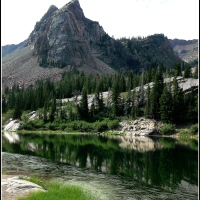
And now those surrounding mountains and valleys…astoundingly beautiful…

A closer look at what is actually the eastern side of Mt. Olympus….

I asked another hiker to take a picture of me on the summit, but this one is more interesting, the National Geodetic Survey marker planted on the mountain-top in 1973.

And finally, near the last quarter of the trip back down the mountain pathway, it was like entering a forest cathedral with the living arches of a beautiful sanctuary….

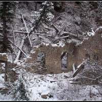


wow, that’s super ugly. can’t believe i’m leaving behind this beauty for that….
June 12, 2011 at 6:47 pm
You’re funny…. 🙂
June 12, 2011 at 6:49 pm
Holy MOTHER OF FRANK! BOU BOU BOU BOU BOU BOU BOU BOU!!!! That…is…my…home…I love it 🙂 Should I take some pictures of the dirt clods?
June 13, 2011 at 7:19 pm
Holy Mother of Frank?! I love it…and yes, BOU to the extreme…and home, ’tis home. I’ll pass on the pictures of dirt-clods, thank you, though, not. Come back….
June 13, 2011 at 8:32 pm
Where is the summit marker? I couldn’t find it when I was up there! 🙂
May 28, 2014 at 8:43 am
There is a National Geodetic Survey marker up there…drilled into one of the rocks on the summit…flat gold thing…there is a summit-log, also….in a plastic bag tucked among the rocks up there.
May 28, 2014 at 9:05 am