Suburban-urban adventure
Hmmm…racquetball…hiking…birthdays…knees…. My exercise for the past almost two months has consisted of walks around the circuit of the underground parking garage at work, five laps of which equals 1.15 miles. It’s too warm during the day to walk outside with Phoenix temperatures ranging lately from 99 to 106 degrees, so I walk underground. Five laps at lunch makes me sweat…two laps at a time during stolen 7-8 minute breaks from my desk just makes me warm and is doable. I’ve not been hiking for months, like almost a year of months. Anyway.

I left the house with camera a couple of Saturdays ago at the same time I normally leave with my son to take him to work and then myself to work. I wanted to capture something of the sunrise near the cultivated and fenced meadows where horses graze at 60th Avenue and Thunderbird. I have seen them in the mornings and wanted to see them on my own when I had nowhere else to be. It held a promise that wasn’t fulfilled this morning.

The horses were too far away from the pipe fence boundary keeping me out and the sun was too far behind and to my side for me to be able to even see anything that was resembling of what I hoped to find. I did stop, however, and made a few images of horses grazing, trees biding their lives in their row-planted places between meadows, and then left to find something else.

I found coffee at McDonalds, an image of a jogger heading south and east along the canal bank from 43rd Ave/Peoria, found some images of Prince on the wall next to Rodriguez’s Boxing Club at 15th Ave/Roosevelt, and then found myself at La Canasta, at 7th Ave/Grant St, purchasing a bit of Mexican wonderfulness.

I took my goodies to Encanto Park, at 15th Ave/Entcanto Blvd, where I sat and watched the quiet morning further unfold as mothers pushed their stroller-bound little ones along the sidewalk, transients sitting on cement benches watching those same young mothers walk past, and another likely transient, a severely aged man with full white hair and beard, baby-stepping from his evening’s bed in the grass heading toward the park’s restrooms.

I wanted to go ask him if I could take his picture, to add that experience to my memory files of uncomfortable things that I have made myself do, but I had no cash to offer him and had only my half-eaten burrito, something that I was not going to offer or relinquish for a couple of photographs.

The twenty-or-so-minutes that I spent at the park was full of memories, anyway, as consuming the particular burrito that I had ordered sparked an opening of old folders from when I worked at the police department and with the health department the first time.

The burritos were a favorite Saturday or Sunday morning treat, often bought with bags of chips and salsa to share with coworker friends on the supervisors’ pod. Other times, it was just me at the park alone, sitting in my vehicle or at a bench having a burrito and watching the morning or afternoon foot traffic of park visitors or denizens as they made their various ways or circuits along wherever.

I was going to return home then, but thought I would head down to the river bottom at 7th Ave just south of Watkins and see what the restoration area looked like, to see if I might enjoy a still fairly early morning walk along the river’s greenery and then. I parked at the west lot and went down and under the overpass and slowly headed east on the paved walkway, then stepped off and continued along on the parallel graveled service road.

I encountered a friendly transient who mumbled a “good morning,” and then continued eastward along the “river and through the woods.” There was not a full canopy of trees with their cathedral arching boughs, but it was often shaded and comfortable enough walking nearly beneath the desert riparian vegetation.

The goal was to go from the 7th Avenue trailhead east to 16th Street and then back again, but I encountered several fences blocking my way, as there had been construction to repair the 7th Street bridge over the river from where it had been damaged in last year’s monsoons.

I did not find any “no trespassing” signs, so I went around a couple of the fences where they ended at the river bank, scooted between two panels that were ajar because of their position on the downward slope of the hillside up from the river, and then walked through an open gate when I found one.

Desert…water…dense vegetation…incongruity….

I was past the 7th Street bridge, a mile from my starting point, and heard a construction worker yelling down or at someone while he appeared to be pointing out in my direction, but I kept walking in my casual pace and making photos of a white egret that I happened to see on the far bank.

Having heard the construction worker yelling and pointing, apparently in my direction, caused a bit of unease, so when I encountered another fence about a quarter mile before my intended goal at 16th Street, I turned around and headed back to my truck.

I was approaching the overly-warm condition that told me that I needed to turn around anyway, so it was good to do so. Unfortunately, I hadn’t brought any water with me, so I was starting to feel stupid, as well as overly-warm. And fortunately, my animal brain was still alert enough to notice a snake-like something in the shadows that my then-awakened and present mind discerned to be a piece of rope.

For context, I will add that this is the Rio Salado River that passes through the metropolitan Phoenix area about a mile or so south of downtown. Its origins are far north and east of the valley; it is dammed-up at “Roosevelt Lake,” and then flows, when it flows, down to the Phoenix area, fills the “Tempe Town Lake,” and then continues westward into Phoenix proper. The river bed continues south and west, beyond my experience and detailed knowledge, and way far away. Back in the early 2000s, the City of Phoenix spent over 10 million dollars restoring a stretch between 7th Avenue and 24th Street, cleaning decades’ worth of trash and dumpings, and then planting native riparian species all along the river bed.

There are even locations where fresh water is piped-in to the area, keeping water in the river bed throughout the year. Driving over the bridges at 7th Ave and 7th St, and even to a lesser degree at 16th and 24th Streets, one can see the intense greenery around the riverbed and be tempted to forget that one is actually in the middle of the Phoenix desert. That’s actually a blue/gray heron in the above image.

When I researched the riparian restoration project a few years ago for an earlier blog post, I was surprised to learn that before the river was dammed and formed Roosevelt Lake, it used to flow at such a depth and breadth that there was a ferry service used to cross the river, many years ago.

It was nice to be out there again. Yes, I could see and hear the road and air traffic around and above me, could hear the beep-beeping of construction vehicles moving and backing around as the drivers were doing their work, and I could see the various warehouse and other light-industrial buildings hundreds of yards away on both sides of the river…but I could also see the intensely green natural and other vegetation surrounding the river, see reeds and sedges and other things that have no business being in the middle of the urban desert where I found them.

I saw pigeons, mourning doves, sparrows, some type of woodpecker, quail, ground squirrels, cotton-tail and jack rabbits, a grey/blue heron, a couple snowy egret, several lizards, and too many dragon-flies to count. I enjoyed that I was there and able to moderately participate in Nature again, to appraise my human weaknesses and strengths against the essentially mild desert environment…to feel stupid at being there without water, and to feel relief when I made it back to my truck and had the A/C blowing full-force into my face for several minutes while I drank the bottled water that I had there in the cab…

…and then to be alive later, here at home, sitting in my recliner in the A/C cooled TV room with music playing quietly in my headphones, with a cup of ice-cooled Gatorade at hand…with leg muscles telling me that I had been out hiking/wandering further than the neighborhood circuit where I usually walk on the weekends or the parking garage circuit where I walk during the week. Yes, in the broader context of my experience, it was “nice.”
Watson Lake, Prescott – and surround
Watson Lake is situated in an area known as the Granite Dells…weather-worn remnants from another geologic era. There is another lake a bit to the north and west named Willow Creek Reservoir. I haven’t been there yet, so that’s another Prescott adventure for the future.

The brochure for Watson Lake states that it is four miles northeast from downtown Prescott, Arizona…it is also 98 miles from my driveway in the far northwest valley of metropolitan Phoenix, more precisely, it’s that far to the parking lot for the Peavine Trail…a former rail-bed turned hiking trail that runs along the southern edge of the lake and beyond.

I follow an Arizona hiking page on another social media site and have seen numerous photos or posts about the lake and its very immediate environment. I have not, however, seen any images from the trails that circle the lake, nothing from the greater setting in the Granite Dells…and, actually, nothing beyond intimate photos of water reflected boulders and beautiful sunsets.

The above image is the only one that made it into black and white. The location was in the shadows of the cottonwood and other trees in the southeast corner of the lake, and while it provided great access for longer views while approaching the lake, it was difficult to capture significant color in the immediate area.

My original plan was to hike the majority, if not all, of the Peavine Trail. I understood that it was somewhere between 11 and 12 miles in length, and that was what I wanted…a nice long hike…situated near the lake…close enough to it that I could make some images of my own.

Shortly after passing the above location, I ventured off down one of the shore trails and wandered around looking for photo worthy settings that weren’t too effected by the morning’s sun and shadows. I didn’t have much luck….

So it was back on the Peavine Trail heading northeast again, parallel to the lake…and going away from it.

The lake and surrounding property now belongs to the City of Prescott…literature claims they took possession of it in 1997 in order to protect it and to use it for recreational purposes, etc. In their efforts to make it more user-friendly, they placed weather-protected maps on sign posts along the way informing the hikers where they were in relation to the lake, which trails they could take, distances covered, etc.

When I noticed that I was going to be heading too far away from the lake on one of the trail-side maps, I decided to take the “Over the Hill Trail” back to the greater network of the “loop” trail that essentially circled the lake. Given that much of the trail was over exposed rock and was not discernible as an actual trail, the Parks Department painted white dots on the granite to mark the way. You can see one of the dots to the right and down from the tree in the center of the above image.

The “Over the Hill” trail led down to Granite Creek, which we can see in the lush green toward the bottom of the rocks….

When the Over the Hill trail intersected with the Granite Creek trail, it was initially unclear which way to go…right or left. Heading toward the right led to waist-high grasses and very soggy walking, as the trail through that tall grass was actually under water.

Turning back to the left brings us back to a clear trail, still through tall grass, but alongside the creek, and then (not marked), heading over the metal walking bridge that you can see directly above the tree that is in and over the water.

Another thing that the juncture of the two trails mentioned above brought to me, was the sound of a waterfall…that very particular crashing and rushing of water kind of sound that means water is flowing hard and fast somewhere nearby. As you can see above, it wasn’t exactly a “waterfall,” but is was definitely falling water…hard and fast and loud in the half-circle of the concrete and canyon walls.
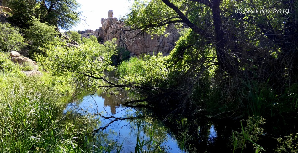
This is still a desert, supposedly…high desert…5,000 plus feet in elevation…stream-side…marvelous…wonderful…green….

Exposed granite slabs, rolls, pressings…and I imagine it would be hotter than the blazes with reflected heat on a true mid-summer day…

The first glimpse of the lake after rounding the granite hills…now perched on what is the northwest corner/curve of the reservoir….

*****

*****

The front side of the dam, above….

Heading back down south and west….

*****

A cormorant congress above….

Looking back north and east….

A closer look at the heron in the backwater toward the far south and west…nearing the Discovery Trail….

…and now into the deep cottonwood shadows that we skirted at the beginning of the hike…beautiful shade and cool breezes.