Fire on the desert morning mountains….
On the first morning of summer, 6-21-2020, at 0439 hours…a glow on the horizon that didn’t belong there.

I was heading north to go hiking in something like a desert riparian paradise…nine minutes into the trip, following the freeway north and then east…rounded the curve and saw the above view from afar…probably a couple dozen miles…

…smoke in the draw between the ridges…

…north of New River…north of North Phoenix…

…wild…

…and disconcertingly beautiful…

Referred to as the Central Fire in local media…burning since the previous day.
Hiking the Peralta Trail – Last
It was five months ago yesterday that I took the hike and made these photos, so I should probably finish the series and post the images that have been sitting here in draft form since February…

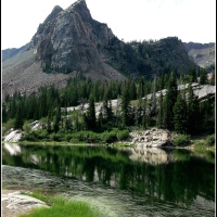
You might remember from the previous posts that there was a chance of rain and that the skies were overcast for most of the hike…. You might remember, as well, that the significant landscape feature of the hike was Weaver’s Needle….

I had hiked out to that lone pinion pine in the above photo and made some closer-up images of the Needle…and also in the above photo, if you can imagine us to the far right and out of frame, that is where I was when I made the first image of this post, looking south and east from that bit of a plateau that leads to the pine tree. I was heading back to the Fremont Saddle to descend the trail on the hillside that would take me down and to the west of the Needle when I made the above photo.

On the level trail now, still looking at the southern aspect of the Needle…in among the rich desert foliage that was largely unfamiliar to me, but contained some type of willow, mesquite, and occasional palo-verde.

It had rained earlier in the week and the park ranger said all the streams had stopped flowing. The rushing course had stopped, but the water was still seeping slowly in the deeper parts of the canyon, still moving enough that I could hear the occasional trickling that seemed so out of place in my surroundings.

The desert is not all dessication and waste….

If I had more time, I would have enjoyed climbing the hill, walking around the Needle, and capturing some images of what the prominence looked-like up close and personal.

Looking at Weaver’s Needle from the north…the Fremont Saddle is reached by going back through that rich path of green toward the right and climbing the switchback trail up to the lower portion of the horizon just below the patch of blue in the photo above.

Clearing skies on the way back…looking toward the north…

And then the broader view, looking north again, from the beginning of the switchback trail leading up to the Fremont Saddle.

One of the last photos I made of the hike back, heading down the trail from the Saddle, through the “hordes” of other hikers making their way up to it; I stopped to capture an image of the rolling purple waves of the Superstition Mountains…and the Tolkienesque sandstone spires that adorned the ridge of the western aspect of Peralta Canyon.
If you’d like to take another look at the earlier two posts on the Peralta Trail, you can click here and here.
As always…thank you for visiting. I hope you enjoyed the little glimpse into Arizona’s Superstition Mountains.
Hiking the Peralta Trail – Middle
This second installment begins where the first one ended, right at the Fremont Saddle…the geographic/landscape feature that appeared to be a resting and turning-around point for many hikers. That was my impression, anyway, as there were a few people who walked out to the lone Pinon Pine in the distance, and many fewer people who actually went down the trail that eventually led to the base of Weaver’s Needle in the background…and swarms and tons of them at the saddle and back down on the first half of the trail as I made my return trek.

This second image is the view to the left of Weaver’s needle, made from the same location as the one above….

There is actually quite a gulf of rock-filled space between that lone pine and the southern edge of the base of Weaver’s Needle, even though some of the following images offer a view that appears somewhat contrary to what I just stated.

If you can return to the first image above, find the two people, and then travel in your mind in a sort of quarter or third of a circle off to your right, you will come to the location where I made the below image…it’s looking somewhat off to the southeast…over a further expanse of rocky and bouldered desert that contains dozens of other trails.

Crazy waves of mountain tops and yucca stalks….

Approaching Weaver’s Needle now, coming from the southeast where the above image was made…with a somewhat serpentine trail drawing us closer. You can see two people on the trail….

And below, facing somewhat northeast over the rocks and mountains of the Superstitions. I shared this image in a black and white rendering a few weeks ago….

It appears that we’re getting really close now….

Don’t forget to look down…and pay attention to what’s there….

Final yards up to the lone Pinon Pine…a feature that is discussed on-line as another favorite destination and turn-around spot. I encountered a man and woman (and their dog) who appeared to have spent the night under the pine…and were packing to leave as the other hikers and I arrived…rested, lingered, and then departed to continue our respective journeys.

This is the view from the ledge just down and to the left/west of the pine tree…there is quite a bit of space between the tree and the Needle…..

More to follow….

Hiking the Peralta Trail – First
The Peralta Trail is just one of the almost 40 trails that one can find in the Superstition Mountains of Arizona. The mountains are part of the Superstition Wilderness that lies within the confines of the Tonto National Forest. I might have mentioned it in the earlier post, but my visit to this bit of desert a week or so ago was my first…. I have only driven “close” to the area a few times in my two-decades-plus of living in Arizona…and by “close,” I mean maybe within 20 miles…or more. The photo below was made about 17 minutes before “sunrise” proper, so it’s a little dark…even with some “fill light.”

I didn’t really know what to expect when I arrived at the canyon. I did know, however, that I would be following the trail, out and back, so I didn’t research the actual trail, other than to learn where to find the trailhead. I did not check-out Google’s images of the trail or the mountains. I wanted everything to be fresh…wanted the neuronal memories to be of things that I actually saw….

I spoke with one of the National Forest attendants who was milling around the parking lot and he said that all of the streams had stopped running by then, said they were going earlier in the week with the rains, but that I shouldn’t have any difficulties crossing the stream-beds during the hike. This one was still actually “running” when I encountered it on the way out, and back several hours later…but it was much nicer when this photo was taken, as I was the only witness of that particular moment of the day….

Above and below, two images of the same mountain from different perspectives, different times and elevations…further along the trail with the second. I suppose I could mention here that all of the photos are presented in time order…for this and the following two posts…all the way out and back.

It was all quite new to me, as I mentioned earlier…a richness of green in the middle of the desert…green at the present because of the Winter rains and cooler temperatures…a seasonal reprieve from what I understand to be hideous temperatures that ride there in the middle of the year months. The rock battlements in the lower photo were an accompaniment for the greater portion of the first part of the trail…they subsided somewhat…changed, rather, as the trail went further up the canyon.

Looking back-trail again in the below photo…amazed again/still at the greenery…

And then comes the company…at least it was a dog…with a human trailing behind…two of them, actually, but quite ones…a girl-pair with their purple hair…and lip piercings…and water bottles and backpacks…on the trail of a Sunday morning…

*****

I guess the one above is a closer view of the one below…climbing higher again.

…and this one, too….

….anyway, it was damn beautiful out there and my sense of amazement only grew as the trail climbed in elevation….

Pretty and crazy rocks….
A little bit of Superstition….
It was almost 85 miles from my drive-way in the far northwest valley to the trailhead in the extreme southeast valley, just across the county line, just beyond Apache Junction, just past Gold Canyon…and well worth the drive.

Seven hours on and off the trail, almost 300 photos later…an overcast day with the sun barely peeking out from behind the clouds for an hour, and then retreating back behind them….

While I was hiking in near solitude on the way out…it was like fighting an infestation of lice or mites on the second half of the return trip…walking people, talking people, loud people, colorful people, children people, slow people, dogs with people…and people people….

But before the people…the views…the cool morning air…the rocks and greening desert…and the slight murmuring and chuckling of a diminishing canyon stream….

This was my first trip into the Superstitions…and I will be back.

More to follow….
Seven Springs Saturday
I drove north and east this morning…this false first-Saturday in this new and old place. The true first-Saturday found me unloading moving trucks, you might remember…so this was the first one that was unoccupied with moving and other commitments. Like I said, I drove north and east, trying to get closer to a huge mesa in that direction which has been unimaginatively named “Table Mesa,” which to my understanding of Spanish, ends up meaning “Table Table.” At any rate, I found myself only in the vicinity of that place, several miles, really, away and away from the redundantly named mass of earth and rock that rises table-like from the lower desert floor. The below image is not of that so-named bit of earth and rock, it is of other bits of desert hillsides and ridges and crowning greenery and thorns and chunks of volcanic waste that was left behind after their own genesis in the eons of millennia passed.

After completing something of a circle of exploration of that land to the north and east of my current desert home, I headed further north and east along new, yet known roadways…heading toward another desert town that lived in my mind as a memory of only a brief visit that occurred nearly 30 years ago. Along the way, however, I encountered a sign that said “Seven Springs,” a notion of a recommended place that I in particular might enjoy…”It’s green,” she said, “with a stream and cottonwood trees…,” things that reminded me of another place, one that I have only recently left behind…. The last image in the below gallery shows what the area looks like from above, rather…a nearby area that is strikingly similar to the visited Seven Springs….a flowing greenery that lives in the narrow draws and folds that lie between rolling hills of raw and scorching desert sand and rock.


I don’t know the name of the delicate flowers in the below image…but I found the plant along the waterway of Seven Springs….

…and a yellow Columbine, too…a different version of my favorite flower ever, the Colorado Columbine that I shared in this post if you’d care to see a similar and beautiful creature in pristine, alpine white….

This Saguaro Cactus is probably close to 25 feet in height…one of what must be hundreds and hundreds of the amazing plants that populate the vast Sonora Desert of Arizona.

Forgive the slightly washed-out white of the Saguaro’s blossoms in the below image…today was one of those days that my sons refer to as “severe clear,” meaning that there was not a cloud in the sky as the June sun beat down upon the desert….

Roadside Prickly Pear Cactus…under a near-noon sun….

Hmm…maybe a little fuzzy on the yellow….

…and lastly, looking down the hillside into one of the desert draws…you can probably make-out the dry waterway…a sandy pathway that leads to the greener foliage in the upper left of the image…early Spring rains and Summer monsoon storms bring the stream-beds to life again….

Thank you, Rachel….