Lake Florence in the Morning
You might remember the lake from last year when I did the posts on the Sister Lakes of the Wasatch Mountains. You can click on “Sister Lakes – Lake Florence” to learn more about this lake. The earlier post also has links to the other Sister Lakes if you’re interested in the more complete history of the area.

Dromedary Peak…twice…..
This is an early-June, 2013 photograph of one of the iconic mountains that provide a backdrop to the Sister Lakes in the Wasatch Mountains of Utah. Found at the terminus of the drainage or tributary canyon, Mill B South, it is a frequent site and common reference when trying to orient one’s self while hiking in this area of Big Cottonwood Canyon. If you’d like to see other images of Dromedary Peak, you can scroll to the bottom of the page and type its name in the search widget to be provided with a list of other posts that contain photos from other seasons.

Spring run-off in the Wasatch
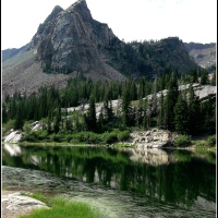
This particular location is found just down from the drainage at the lower and west end of Lake Lillian, one of the Sister Lakes in Big Cottonwood Canyon, just south and east of Salt Lake City, Utah.


Dromedary Peak under Snow
It looks a little different than it did in this earlier post…but I believe it’s still full of an incredible and natural beauty….


Sundial Peak in Winter
You might remember Sundial Peak from various posts over the summer…and into the fall…possibly from the one dedicated specifically to Lake Blanche, one of the Sister Lakes located at the end of the drainage, Mill B South, up in Big Cottonwood Canyon…tucked away in the Wasatch Mountains…just south and east of Salt Lake City, Utah, USA…. It took twice as long to get there with the deep, deep snow…even with snow-shoes…but, oh, what a reward at the end…..

Dromedary Peak in January
I think it rather looks like a pencil drawing…but this is the image, essentially right out of the camera…I have only cropped and framed it…not messed with the color in the least. If you’d like a summer comparison, you can click these words to be taken back to an earlier post that shared images from July, 2012.


Sister Lakes – Lake Florence
You might remember from my earlier post about Lake Blanche that there are three sister lakes situated in what has been referred to as the Hidden Valley…at the end of a drainage or tributary canyon, Mill B South, which extends off of Big Cottonwood Canyon, just south and east of Salt Lake City, Utah, USA.

I think I’ve probably already provided as much of the interesting history of the area as I might, so the remainder of this post and the following one on Lake Lillian will be simply sharing the natural beauty of the area. You might recognize Dromedary Peak in the photo above from another earlier post…as you can see here, it provides an appealing backdrop for Lake Florence…and Lake Lillian, as well.

The above photograph shows another side of Sundial Peak, which you might have seen in a couple of other posts, but probably most significantly in the Lake Blanche post referred to earlier. The rocky and beautifully treed ridge above is what you would find between Lakes Blanche and Florence…and in the below photo (taken in July, 2011), you see the waterfall/drainage that leads from L. Blanche to L. Florence. With the greatly diminished snowfall this past winter season, there was very little water flowing between the lakes this year.

The next three photos are very similar, but demonstrate slightly different perspectives of Lake Florence and the rocky backdrop of Dromedary Peak. You might notice a couple of people toward the right side of the second photo below…I don’t know who those folks are, but they had camped at the location overnight and help to add a bit of dimension to the beautiful orange/red rocks that form a portion of the bowl for the lake.

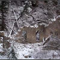
As I mentioned in the Lake Blanche post, dams were built on each of the lakes to preserve a certain amount of water per year…water that was collected from the snow-melt that occurred each spring. The dams were built over a period of several years, started in 1905…completed in 1934…and then breached in 1972 when they were deemed no longer necessary.

If you look closely, you can see a small portion of Lake Lillian…right behind the skinny finger of a dead tree immediately to the left of the dam…on the far left side of the above photo.

For those who are interested, the trail that leads to the Sister Lakes is approximately three miles/4.8 km in length and has an elevation gain of about 2,600 ft/792 meters, with Lake Blanche being at about 8,900 ft/2,713 m and Lake Florence, 200 yards/183 meters to the west at 120 feet/37 meters lower. Sundial Peak is measured at 10,320 ft/3,146 m, Dromedary Peak is at 11,107 ft/3,385 m. The entire Sister Lakes area falls within several thousands of acres that are designated as the Twin Peaks Wilderness Area, which is part of the Wasatch National Forest.

Aside from the beautiful reflection of the ridge in the above photo, you can also see where the waterfall is missing (mentioned in regard to photo #3) in the rocky cleft near the middle of the image.

Wildflowers on the little ridge behind the dam on the far west side of the lake…I checked six on-line resources and can’t identify them properly, but I’m guessing that they’re from somewhere in the Sunflower family….

Similar images, above and below, but from different perspectives….

I’ve included this last photo from July, 2011, so you can see Lake Florence with a bit more water in it…and with a nice snow-patched mountain back-drop…you can also see Lake Lillian in the background.

I hope you’ve enjoyed visiting Lake Florence in the Wasatch Mountains of Utah. The next post in the series will focus on Lake Lillian, the smallest of the Sister Lakes in the Hidden Valley area of Mill B South, in Big Cottonwood Canyon….
Broads Fork – Part I
I would guess that there is some historical significance to the name, but I haven’t been able to identify it yet…but Broads Fork itself is located about four miles into Big Cottonwood Canyon, which is just south and east of Salt Lake City, and is one of the three or four main canyons that lead into the Wasatch Mountain front that is the eastern border for the Salt Lake Valley. The trail is reported to be just over four and a half miles in length from the parking lot to the cirque, or bowl-shaped meadow at the end, and gains just over 2,000 feet in elevation.

I’m not sure of the exact length of this portion of the trail, but it starts out as something resembling a logging trail and then turns into a single track that winds through very thick brush that is often waist to shoulder high….

I haven’t been able to identify these flowers in any of the sources I have at hand, but they look like a variation of hops to me….
UPDATE: While I was out hiking yesterday, Sunday July 15, I met Knick Knickerbocker from the Wasatch Mountain Club and gave him one of my blog cards. He emailed me this morning after reading this post to tell me that these flowers are called Mountain Horsemint…and the taxonomic name is something like Agastache urticifolia…if anyone wanted to know that. Thank you again, Knick. 🙂

This was the first view of what the on-line literature calls the “lower meadow” in Broads Fork. After climbing through old-growth pine forest and then a thick stand of aspen and the brush that I mentioned above, the trail makes a sharp turn around a rise in the terrain and this panorama is suddenly in front of you…it is so unexpected…breath-taking, jaw-dropping, however you want to describe it.

This is the view looking to the left of the above meadow….

The trail proceeds through the meadow and immediately into a stand of aspen and pines, again with the thick brush on each side…slowly climbing higher and higher as it makes its way out of this lower meadow and on toward the upper meadow.

When I’m hiking, especially when I’m on a trail for the first time, I frequently stop and turn around to take a look at the trail coming from the opposite direction…it helps with orientation on the way back if I will be taking the same route. It’s amazing sometimes to see what’s behind you as you come out of the woods, arrive at the top of a ridge, or otherwise gain a dramatically different view of your surroundings than you had only moments before…. This is the view I encountered upon leaving the thick aspen that covers the side of the bowl where the lower meadow is situated. I stood on the rise in the trail as it makes its entry into the upper meadow and turned around….

Here’s an infrequent “people picture” offered to demonstrate scale…. It’s rather difficult to feel significant or important out here…the notions of “Self” and “Me” seem to disolve somewhere between the first few steps on the trail…. This photo was taken near that rise in the trail mentioned above, but a little further down and facing into the second meadow, and with a nearly full view of the rest of the fork or gulch.

And this is a wider view that encompasses more of the area to the right of the location in the above photograph…I understand the peak in the middle to be Sunrise Peak, the one on the left to be Dromedary Peak, and the one in the upper right of the photo to be the western peak of the Twin Peaks set. The western summit has been measured at 11,330 ft and the eastern summit at 11,328 ft in elevation. These peaks are reported to be the tallest of the Wasatch Mountains that border Salt Lake City.


More to follow…in Broads Fork – Park II.