Antelope Island in September
You might remember my earlier posts, Field Trip to Antelope Island and Antelope Island – Part II, from February and March of this year. I had planned on returning to the island sometime during the greener part of the year, as I wanted to capture some images of spring-rich rolling hills and vibrant Sunflowers. Well…we didn’t make it back during the greener time of the year, but the Sunflowers were still thriving, despite the golden brown hills that spoke of a very dry summer out on the island.

My second son and his son….

Beautiful Sunflowers with the Wasatch Mountains in silhouette in the background….

If you’re not familiar with Antelope Island, it is the largest of several islands out in The Great Salt Lake, Utah, USA.
My daughter (in-law), wife of my son mentioned above….

You might remember this tree stump from a couple of earlier posts….

The Pronghorn Antelope from which the island gets its name….

Grandson and my little one (on the right)….

This last shot was actually taken out on the seven-mile-long causeway that leads from the mainland out to Antelope Island….

More to follow….
A Taste of Autumn in the Wasatch Mountains….
I spent several hours hiking the trails and mountainsides of Little Cottonwood Canyon this past Sunday…and was amazed at the sights that greeted me with nearly every turn of the trail…. I hope you enjoy this little glimpse into my corner of paradise, courtesy of the Wasatch Mountains, just east of Salt Lake City, Utah, USA.


Bald Mountain
This is the likely the last post from our little excursion up to Mirror Lake in Duchesne County, Utah, USA. If you’d like to view the other images again, you can click on these highlighted titles: On Water and On Mirror Lake.

How much longer…?
Innocence smiles large as the boys rescue The Cube and ride their motorized scooter and roller-blades about the cul-de-sac, announcing to me in passing that they are on their way to destroy Megatron. Hood up on his sweatshirt jacket, my little one is on the roller-blades and moves awkwardly about, wheel-walking, not rolling, strange dance of plastic and clatter rushing off to secure some imagined zone.
The December sky is gray with fat and heavy clouds; an occasional breeze or gust of wind ripples the overgrown palm fronds and the garbage truck is making its Tuesday afternoon rounds in the neighborhood a couple streets in the distance. My grandson is on the motorized scooter and is wearing orange, star-shaped sunglasses to shield him against the glare of battle in his efforts to defeat the Transformers’ foes. My little one’s enthusiasm for the game is waning as a little trio of afternoon walkers enter and make a circuit of the cul-de-sac – a young mother-girl pushing her baby in a stroller as grandmother walks with her Down’s Syndrome old-man of a son in a straw cowboy hat who marvels at the Samoyed who is sticking his nose and white head through the hole at the bottom of the neighbor’s backyard wall. The cling-cling of the bicycle bell and the metallic crash as the bike crunches into the sidewalk and the garbage truck is still a few streets away.
“Can we go in now?”
“Don’t you want to play two-player on the Nintendo?” he says, as he kneels in the rocks and examines a pigeon feather, “Don’t you want to?”
“No, not really.”
“Dad, can we go inside in 15 minutes?”
Ok.
He likes to orient things and events and know when they are going to happen. It helps him predict his world. He’s happier and less anxious that way. It settles his mind as the blanket of gray clouds part and roll into white balls with gray bottoms and a mini-bike just ripped and popped down the street behind us, throwing angry and irritating ripples and waves through the neighborhood air.
“How long has it been, Dad?”
What?
I’m reading my new book, The Good Soldiers, between glances up and into the cul-de-sac and at the Transformer warrior-children and vehicles entering for deliveries or exiting for errands and whatnot.
“How much longer?”
“The post is loose on the scooter, Grandpa,” as he sucks the winter snot back into his nose and as the little one, his uncle, my youngest, talks to his dog through the side-yard gate….
“Hi Wilson,” sing-song, puppy-talk, baby-talk, talking-to-my-dog-through-the-gate-talk, sing-song “Hi buddy!”
Crunching gravel, walking scuffing, scraping, and dragging shoes through the landscaping stones. Ping! Ping! Ping! Ping! Ping! A piece of gravel rock on the basketball pole. Ping! Ping! Ping!
“How much longer, Papa? How mucho longa?”
I’m on page 27…For now, no one touched the tape dispenser. Eventually, Cummings would begin swatting flies just hard enough to stun them, stick them to a piece of tape, and drop them alive into his trash can, which would be something that did have an effect. “I hate flies,” he would say each time he did this. What?
“Is it time yet?”
Did you park your bike and scoot it all the way over so Mom can open her door after she’s parked the car?
“I will.”
Ok.
“Are you done Blakie? Hey!”
“What?”
“Do you want to go in now?”
Cling! Cling! Cling! “Beep beep!”
“There’s a warning.”
What, Blake?
“There’s a warning.”
What kind of warning?
“There was a rain drop.”
Oh, ok.
And the garbage truck is getting nearer and the little one is dragging his toes across the driveway and he’s got a Kool-aid moustache as he grins at me and says “What?”
“How many more minutes? Dad?” as he stands on the apache-red boulder rock in his one-legged pose with his arms raised like a stork’s wings…from The Karate Kid…and a game of chicken in the roadway as my grandson comes at him on the motorized scooter…and repeated “Yaaaaah!” screams and “How much longer?” asked with a Pink Panther French accent this time.
“Hhow mush longherre?”
One minute.
“Ok……Blakie!! It’s time to go in!”
***This is a Favorite Re-post from December, 2009.
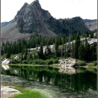
Sister Lakes – Lake Blanche
The Sister Lakes are situated near the end of a drainage or tributary canyon that is referred to as “Mill B South” in Big Cottonwood Canyon, just east of Salt Lake City, Utah, USA. The canyon is one of three prominent canyons in the Wasatch Mountains that provide the eastern boundary of the Salt Lake Valley…and all of the canyons are part of the Wasatch National Forest.
On a technical note, all of the photographs in the post were taken between about 10:00 and 12:30 on two bright, sunny days that were about two weeks apart. I don’t have any filters for my camera, so you’ll notice that most of the clouds are a bit over-exposed. I had thought that there was an adjustment to +/- the exposures, but…I was mistaken. At any rate, I processed each of the photos with Picasa in an attempt to lessen the effect of the harsh light, sharpen the images, and to bring the colors back to what they were when I saw them that morning…and as you’ll see, also gave one or two of them a different finish. I hope you enjoy them.
The below image is of Sundial Peak over Lake Blanche….

The drainage has had this name since 1855 when construction of the saw mill was undertaken. It is my understanding that this mill, and other mills so named with letters of the alphabet, was initially owned by the Big Cottonwood Lumber Company…which was owned by one of Brigham Young’s sons and a few other people. As each mill was built in the canyon, it was given the next letter in the alphabet…but that doesn’t mean that they proceeded in alphabetical order as they progressed upwards in the canyon. The image in the below photo is from just left of Sundial Peak…I suppose that would be to the east.

If anyone is interested enough to search for Big Cottonwood Canyon on Google Earth, you will be able to find Mill B South on the right-hand side of the very distinct “S” in the road that is about 4-5 miles up into the canyon.

If you find that “S” in the road, just to the right of it will be a parking lot…on the upper (east) side of the parking lot, you will find the trailhead for Lake Blanche. On the lower (west) side, you will find the trailhead for Broads Fork…which you might remember from two posts back in July. The area in the below photo is to the right, or west, of Sundial Peak…and that little hump you can see near the middle is actually Dromedary Peak.

If you’re not familiar with the settling of the Salt Lake City area, I’ll provide very briefly that Brigham Young and his Mormon followers arrived in the Salt Lake Valley in roughly July, 1847. I say roughly, because some folks arrived shortly before he did and many others continued to arrive for years afterward…from all parts of the country…and many parts of the globe.
The below photo shows the area a little more to the right of Dromedary Peak, and from a different perspective than the above shot. And yes, that wall is a dam that was breached after several years of the lake(s) being used as reservoirs for the Salt Lake Valley’s water supply. More on that subject in a bit….

After the pioneers and other settlers ravaged the forests in Millcreek Canyon, which is much closer to the early city center, they moved south and into Big Cottonwood Canyon to harvest what they might of the ancient forest that lived there, untouched by anything other than Nature’s hand. Some of the journals and notes from those loggers and saw-mill operators document pine and fir trees with diameters of three and four, and up to six feet across…huge trees.
If you’d like some perspective with the below photo, there are two people close to that igloo-shaped rock that is about 1/3 of the way up from the lower left corner…and again, this is the area to the left of Sundial Peak.

So…the area at the end of the Mill B South drainage has been called Hidden Valley…and in that valley are three lakes (referred to as the Three Sisters), Lake Blanche, Lake Florence, and Lake Lillian. The first lake that you come to at the end of approximately three miles of hiking is L. Blanche…and a few more minutes of hiking will take you to the other two lakes that I will feature in the next two posts in this series. The Hidden Valley has been a favored recreational hiking area since at least the 1880s. Two artist friends who frequented the area named L. Blanche after a mutual friend and the other two lakes after their daughters.
By the way, all of the historical information provided in this and the next two posts can be found in Charles L. Keller’s book, The Lady in the Ore Bucket.

The above and below photos were taken from the far side of the lake, from the shoreline just inside of the wall by the dam.

You have no doubt noticed the wall/dam in the fifth and ninth photos…and will see additional dams in photos for the other lakes that will be featured in this series. In 1905, the Brown and Sanford Irrigation Company applied to the US Forest Service to appropriate a certain amount of water from the drainage stream in Mill B South Fork. It took three years for the approval to be granted and another two years for the dam to be completed. Two years later, the company applied to raise the wall and double the storage capacity of the reservoir…. Evidently, this was quite an undertaking and the company had to apply to the forest service officials repeatedly to grant more and more time to complete the project. When the irrigation company had exhausted the time that the official could legally grant, they had to bring the issue to federal court…twice, each time being granted another four years’ time to complete the project. Finally, in 1934, the dam was finished.

Before the original wall/dam was built, when the snow-melt waters overwhelmed the natural holding capacity of the lake’s basin, the water spilled from its edges and eventually found its way into the stream that leads down the drainage and into the larger Big Cottonwood Canyon Stream. When the dam was being built, the engineers provided a spillway course that led from L. Blanche to L. Florence, and then to L. Lillian…that caused each lake/reservoir to be filled before the excess was directed into the drainage that led down the canyon. Over the years, Salt Lake City purchased the water rights from the federal government…and eventually the reservoirs were no longer needed to store surplus waters…and the dams were breached…that was in 1972.
My son actually made this next photo (below) with his cell-phone….

And just for fun, the next two photos are from July of 2011…they show a water level that is much higher than this year, due to record snow-fall in the mountains during the winter of 2010-2011.


Next in the series is Lake Florence…maybe you’ve seen enough of Sundial Peak by now….


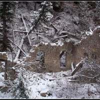
Missing, too….
You might remember the earlier post, Missing…. from several months ago….

You’ll find something similar if you visit Allen at New Hampshire Garden Solutions…but his has a door…out in the middle of the NH wilderness…scroll down to the bottom photo of his post…makes you wonder. 🙂

This hillside bunker might be related to the railroad work that was conducted in Little Cottonwood Canyon, just south and east of Salt Lake City, Utah, USA…you’ll see details of its likely history in the comments on the earlier post. Just click on the blue highlighted word “Missing….” above if you’d care to read a bit more about it.


Sundial Peak in Black and White
You might remember a similar photo from a recent post…. Sometimes things look as beautiful, yet strikingly different, in black and white…they simply do.


City Paint 5.1 – Ironclad Tattoo Re-do
It’s been several weeks since I posted anything in the City Paint series on street art and graffiti that I’ve discovered while driving about Salt Lake City, so here’s a new one that I thought was just too good not to share. I was surprised the other morning to have noticed that Ironclad Electric Tattooing has a new mural. If you’re interested, you can check-out the earlier work in this previous post, City Paint 5 – Ironclad Tattoo. And, of course, if you’d like to revisit any of the other street art or graffiti posts, just scroll down to the bottom of this page and click on the Street-art/Graffiti category.
The first shot is of the entire mural as it appears on the building and the remaining photos are close-ups of the various parts.


I haven’t had the opportunity to learn about who the artist might be, although there is a partial email address of the likely artist(s) in the bottom right-hand corner of the first photo.
Boulder Field
There is just something about walking, hopping, and crawling across massive boulders that freaks me out. It is difficult to put into words the sensation I feel when stepping onto a rock that weighs several hundreds of pounds, and more, and having it tip with my weight. Ever since I climbed the draw between White Pine Lake and Red Pine Lakes and had to cross a similar boulder field that was literally between 400-500 yards across (and after having watched the movie 127 Hours), I have found them to be incredibly anxiety-provoking. You would think that rocks of this size simply would not even budge with just a person’s weight moving on them…but they do….
I took this photo of a fellow hiker, Raj, on the way back from visiting Bells Canyon Upper Reservoir. We had to cross the boulder field twice during the hike, once each way, up and down, and it was unsettling each time. I had actually made the same hike two weeks earlier by myself, and it was even more nerve-wracking….

to celebrate beginnings…
It just dawned on me this evening that today is the three-year anniversary of my blog…

My first post was titled Where it Begins, and this is what it looked like:
“You reach into the black depths of your soul and draw forth words that are of such newness, so silent and naked that they must be blinking at the light and rubbing their eyes as if seeing it for the first time. They are so weak initially that they remind you of newborn mice, innocent and unadorned, without pretense or expectation – but they grow with such hope at each following syllable and sentence, like tiny hearts beating, that by the end they are roaring in their bold elegance, decrying the forces that barricaded them against life and…they speak of emotions and memories that have been so hidden that they were as lost inside their bearer. And you are there….”
A handful of you have been here for the entire time…others for several or a few months…and still others for just a couple of weeks or days…. Your visits, commentary, and feedback have been rewarding, encouraging, and inspiring…thank you for being here, for participating in my world…for sharing in my images and words….
And Jason…if you’re still out there, Noble Sailor…thank you again….
Bells Canyon Upper Reservoir
I have not been able to learn much about the history of Bells Canyon and its reservoirs, lower and upper. The canyon is not even listed in the index of the book, The Lady in the Ore Bucket, that details the history of logging, mining, and hydro-electric efforts in the three Wasatch Mountain canyons that border metropolitan Salt Lake City, Utah, USA. There’s probably a good reason for that, too, given that this canyon is south of the most southern of those three canyons, Little Cottonwood, and does not connect to it by any means.

What I do know, however, is that the lower reservoir is only a 15-20 minute hike from the trailhead…and it takes right around five hours to reach this upper reservoir. The trail is somewhere between four and five miles in length and gains right around 4,000 feet in elevation from start to finish.

I only recently discovered (on-line, before making the hike) that there was a dam at the upper reservoir…and even more recently (after arriving at the lake), learned that this dam has also been breached, similar to the dams at the Sister Lakes in Big Cottonwood Canyon. Construction and modification of those dams occurred between 1908-1934 and they were breached in 1972. While conducting a little more research for this post, I did find a digitized picture of the dam being built in 1914…and I’m still looking for more….

If the Bells Canyon reservoirs were built for the same reasons that the Sister Lakes were dammed, it was so that the water from the snow-melt could be held until it was needed for irrigation and other purposes later in the year when the mountain streams were running low.

I made this hike a couple of weeks ago by myself, but on this particular occasion, Son #3 was able to join me and helped provide some perspective for the scenery in the photographs.

My son is right about six feet tall…which means that the water lines on those two trees are about 10-12 feet above the ground…which means that the water in this lake has been significantly deeper than it was on the day of our visit.

Above is another shot provided for perspective’s sake…there’s a man next to the boulder in the lower right corner of the picture….
And below is a last photo provided specifically for perspective, there are two figures sitting on the left side of the opening in the damn. I shot this one from the mountainside on the opposite side of the lake, so it may lose a bit of its resolution if you attempt to zoom-in too closely on the figures.

The below photograph shows a much wider perspective of the northward view, taken from the same location.

And you’ve seen me before….

This was the last view of the lake before we rounded the bend in the trail, dropped down behind the retaining wall of the dam, and could no longer see it….